| |
| |
Mt Baker Highway (out and
back summit)
Mt Baker Hiway was conceived with
the idea to advertise Mt Baker to tourists. The
road does not actually go to it, but to a scenic
highpoint, named Point Honfoon, very roughly
equidistant between the 10781ft high Mt Baker and
also the 7191ft high Mt Sefrit. Generally I group out and back summits with the closest two way summit ( that is a summit with a least two separate approaches ). But in this case, that is impossible. There are none around. Generally speaking, when riding paved roads in central and western Washington, it is nearly impossible to come up with loop rides over high passes or summits anyway, even on the two way summits, at least not for rides in my limited distance range. So I might as well get used to the idea of "out and back" rides, and also to the idea of a page about an out and back summit.
The lower part is a rainforest ride. With the
right light the moss turns into a hanging garden,
that extends for many miles. Two other paved roads
branch off into the green carpet: East Glacier
Creek Road, just past the town of Glacier and FR31
towards Canyon
Ridge.
In Washington parking anywhere close to an
interesting looking mountain will often cost
dearly in parking fees. Luckily even here,
bicycling in scenic locations is still free - what
a bargain. At "Picture Lake" the road divides for a short
distance, one direction on each side of the lake.
Names like "Picture Lake" are common in American
tourist landscapes. They act as kind of
promotional suggestions on what self respecting
tourists should do here. And the name fits well.
When it is calm (which it often is), snow covered
Mt Sefrit gives off a striking crystal clear
reflection in its water. A trail around the lake
is paved and I carefully rolled along it with my
bike. Just up the road is Austin Pass. This is not a
pass as far as the road is concerned. But a hiking
trail leads down into a small alpine basin. Around
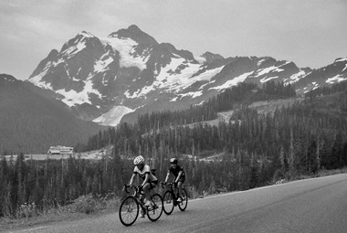
the next turn, Mt Baker makes its first
appearance. So much snow and ice in August - hard
to conceive after all these hot weeks. The day I
am up here the haze from forest fires is
manageable. It gives the mountain an even more
foreshortened appearance than during blazing
sunlight. One more turn and the road ends at a parking lot,
deserving of a football stadium, almost as large
as the one a small distance back at Austin Pass.
The crowds frolic in the snow, and family members
direct each other on how to pose in the
photographs. The crowds here seem more exuberant
than on the top of pass roads, maybe because there
really is nowhere else to go in their vehicles on
this day, except back down to where they came
from. The views are spectacular and the National
Forest Service often has a tent with people
knowledgeable about the local geology, botany,
history, who can point you in the right direction
to the answer of a question about the universe,
including this particular corner. Descending this same section, the valley below
seems to approach quickly, just 2.3 thousand feet.
The proportions of the landscape above is much
larger, than the part that was actually climbed by
the road. That seems to be typical of northwestern
volcano rides.
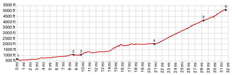
Dayride without Two-way summits, and this out and back summit as highest point: COMPLETELY PAVED: ( < Burpee Hill Rd(sh) | Canyon Ridge Trail s(u) > ) a small distance up East Glacier Road <> down East Glacier Road <> up Mt Baker Hiway with small detour such as viewpoints, parking lots and around Picture Lake << turnaround point Mt Baker Hiway (ows) <> separate short out and back from starting point a short distance up East Glacier Road << to turnaround point at about 1500ft: 50.3miles with 5300ft of climbing in 4:20hrs (garmin etrex30 r4:17.11). Notes: lots of company on this apparently very popular cycling climb, some BC smoke refugees, some Wahingtonians, and a Coloradoan.
|


|
|
advertisement |
|
|
advertisement |