| |
| |
Canyon Ridge Trail -1 s(u)
This trail was mentioned to me by a
National Forest worker and a local mountain biker
as being a great loop bike and hike possibility.I
think the emphasis should be on the "hike". The
trail runs on a steep foothill ridge in the North
Cascades, immediately adjacent to the Canadian
border. Both ends of the trail have a completely
different character.
After this nice warm up climb the Canyon Creek
Road eventually crosses Canyon Creek, and that is
where the loop starts. The profile first goes up
FR3140, a long smooth climb. At one point the
trees open up and a single short view of snow
covered peaks in the North Cascades opens up
behind the road barricades. Later a few views to
the north show ridges used by the timber industry
and snow mobilers in the winter.
Near the top of this road a single prominent sign
announces the Canyon Ridge Trailhead, followed by
a smaller sign that points the way down into the
wild flowers. Could this be all downhill from here
? It certainly looks that way from here. - a fatal
misconception - although the trail looses almost
500ft to arrive in a small basin of thick forrest,
a muddy puddle of a lake, weeds and decaying wood. The next little climb stands out in my memory for
being a tough hike in a wild forest on a deeply
rutted trail, that makes even pushing a bicycle
difficult - often you have to carry it. But the
main reason it stands out in my memory is really
because it was the first pitch that fits that
description. There would be many more yet to come,
than I care to remember. At several point it is
necessary to carry the bike around a detour to the
"trail", because it is impossible to get enough
foothold to get the bike up the deep rut. From the
tracks it is apparent that the only other user in
recent time was a motorcyclist. How he got his
bike over or around the many dead trees across the
trail I will never know. What the trail lacks in views and comfort it
makes up in mosquitoes. It seems like clouds of
them try to land on my eyelides, apparently
mistaking them for landing pads. I must have
encountered this many mosquitoes before at some
time at some place. But never have so many tried
to land on my eyelids. Maybe this has something to
do with all the moss on the trees. Perhaps they
like it there too, and eyelids resemble moss. Of
course they don't all fit on this small helipad,
so they have to be satisfied with the rest of my
limbs, which offer a much larger area to be
bitten. After too many bike-carrying pitches and mosquito
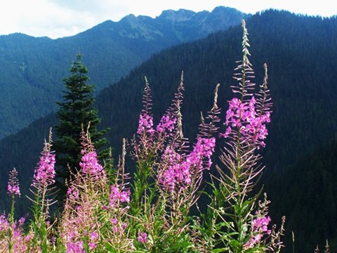
bites than I care to remember, the trail arrives
at a series of two high meadows, bathed in wild
orgy of colorful wildflowers. In the distance
clouds partly unveil a series of vertical peaks, a
regular procession of rocky teeth set into the
landscape. On the other side snowy Mt Baker rises
above it all with its unmistakable shape. For some
time I am tempted to think all that carrying and
scratching was worth it for this moment. But in
the end - this one was just too hard under these
"trail and mosquito conditions". This meadow turns
out to be the highest point on the route. 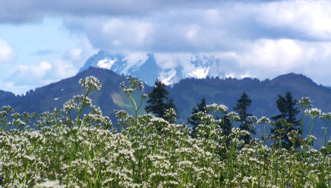 From South-2. (described
downwards). The "downwards" in this case is a
relative term. Yes - the endpoint of the profile
will be lower, but there is still much climbing
ahead, enough to climb a second point that fits
the summit definition. So let's enjoy the moments on this wild beautiful
summit meadow just a minute longer. The enjoyment
moves into the back of my head, as soon as I
realize, that I don't see the trail exiting from
this meadow. The meadow extends quite a distance
to the west, and of course you want to see views
from there. The trail however exits towards the
north, where a Canadian town is visible in the
valley below - definitely a counter-intuitive
direction to go. There are no signs or cairns
anywhere to point the way. The only thing that
works is retaining a cool head and looking for the
trail below in all directions. It is not difficult
to see.
All ridges have to end sometime, including this
one. But it has one more trick up its sleeves. The
vista ahead is of a huge dip leading up to another
summit point. Even though the trail conditions
have improved drastically, so that even somebody
as technically impaired as me can ride substantial
stretches, I am beginning to wonder if I will make
it even to the trailhead before nightfall. But the trick turns out to be - a trick. Just
past the low point on this dip the road becomes
visible below on the right. The visible trail on
the opposite ridge turns out to be part of the
Boundary Ridge Trail. The trail takes a very
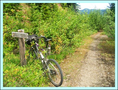
roundabout way to get to the trailhead. Here close
to trail's end, there are even a few signs, the
first ones since the trailhead on the west side. Supringly this trailhead, wich is located close
to the valley bottom, is only 50ft lower than the
western trailhead on the ridge. The last part of
the trail is much more rideable. If starting here,
it gives a completely unrealistic picture of
surface and landscape yet to come. I even make it
back to the starting point just at nightfall,
thanks to a lightning fast descend on a uniformly
sloping, smooth dirt road in the valley, followed
by the paved decent on Canyon Creek Rd.
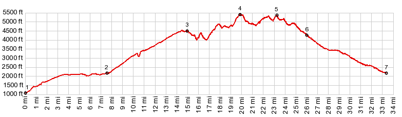
Dayride with this point as highest summit: PARTIALLY PAVED / UNPAVED / HIKE AND BIKE TRAIL ( < Mt Baker Hiway | Barlow Pass > ) Canyon Ridge Trail -1 s(u) , Canyon Ridge Trail -2 s(u) : about a mile up Glacier Creek Rd > down Glacier Creek Rd > up Mt Baker Hwy > up Canyon Creek Rd > up FR3140 > Canyon Ridge Tr west > Canyon Ridge Trail -1 s(u) > Canyon Ridge Tr -2 s(u) > down FR31 > down Glacier Creek Rd > Mt Baker Hwy west > up Glacier Creek Rd back to starting point: 46.2miles with 7910ft of climbing in 8:19hrs (garmin etre30 m5:17.8). Notes: After branching off Mt Baker Hwy I never saw another person or vehicle of any kind - probably because Canyon Creek Rd was closed to traffic because of a road slough. Just to reinforce the "closed" status there are more road blockades, this time for no apparent reason on FR31 and FR3140 (August 17). |
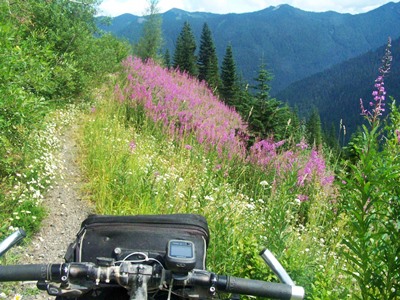
 But the torture on the
trail continues after the short downhill pitch,
although this side of the trail is much more
scenic. It becomes more and more apparent that the
trail leads out onto an ever narrowing ridge
towards high peaks in the National Park. The area
is still deeply forested, but now the forest
often acts like a frame onto grand vistas in
both directions. Without a gps it is is easy to
loose a sence of direction, as the trail meanders
about in wild swings. The dark line representing
the road on the map, draws tantalizingly close
only to recede into the distance again. The second
summit point is not intuitively obvious because it
is preceded and followed by so many other ups and
downs.
But the torture on the
trail continues after the short downhill pitch,
although this side of the trail is much more
scenic. It becomes more and more apparent that the
trail leads out onto an ever narrowing ridge
towards high peaks in the National Park. The area
is still deeply forested, but now the forest
often acts like a frame onto grand vistas in
both directions. Without a gps it is is easy to
loose a sence of direction, as the trail meanders
about in wild swings. The dark line representing
the road on the map, draws tantalizingly close
only to recede into the distance again. The second
summit point is not intuitively obvious because it
is preceded and followed by so many other ups and
downs.|
|
advertisement |
|
|
advertisement |