| |
| |
Loup Loup Pass
Adventure Cyling's Northern Tier
route" follows Wa20 across much of Washington.
Following this route east to west, this pass -
after many miles of forest cycling - gives the
first views of the Cascade Mountains. Of course
the weather has to play along. In the summer this
can be a fairly busy touring route. And since
there is really not that much to see, talking to
fellow bikers sometimes can become the central
part of the ride.
But the road soon enters the forest again, and
the cyclist who yearns for far views (like myself)
has to be content with staring at millions of
trees. As soon as the road gets a little steeper
the shoulders disappear too. The summit has a
sign, and clear cuts in nearby forest testify to
the nearness of a ski area. The big attraction of
the summit seems to be separate parking areas for
skiers and snow mobilers, so that the two tribes
don't get into fights ... like sheep-men and
cattle-men.
From West. (described
downwards). After a roll of 500ft of so, it turns
out there is scenery after all on Loup Loup Pass.
You have to climb an embankment to peer over the
blackened trees, but clearly there in the distance
the Cascade Mountains peak above the grassy hills,
and it is is quite a spectacle. The road seems very steep going down. This seems
to be mostly due to the fact that the road
builders had an aversion against putting turns
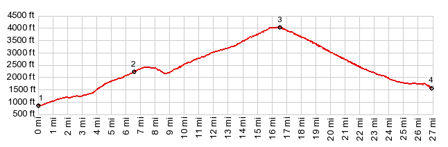
into the road. The profile also does not seem to
show this clearly. Climbing back up it, the small
cogs only get used when carrying heavy touring
supplies. There is no shoulder to speak of, and
traffic can be more than "light" at times. Twisp
has a strip mall, catering to hit and run
tourists, with prices, convincing me, that
actually many things in life are actually totally
unnecessary. ... also a nice town park for a
bring-your-own-picnic by the river. 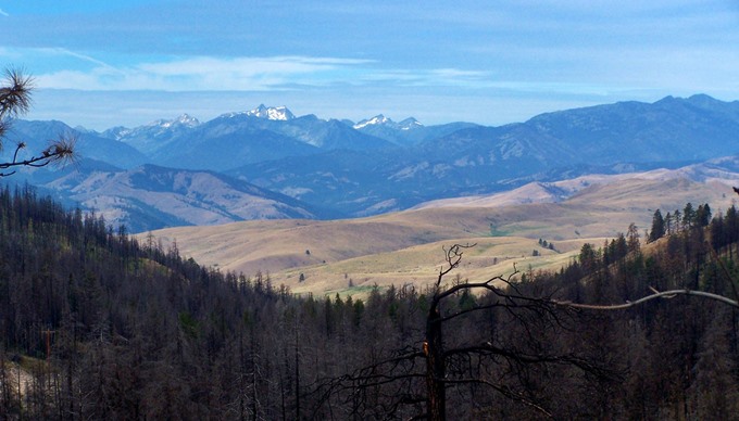 Dayride with this point as highest summit: COMPLETELY PAVED: ( < Wauconda
Pass | FR8220
Cooper Mtn Rd > )
|
 Approaches
|
|
advertisement |
|
|
advertisement |