| |
|
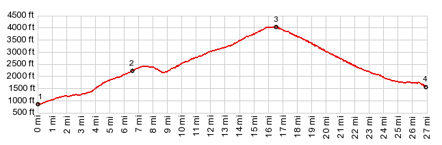
1.(00.0m,0860ft)START-END EAST: low point on US20, just south of Okanogan
2.(06.5m,2190ft)jct with road to Leader Lake on right
3.(16.5m,4020ft)TOP: Loup Loup Pass
4.(26.9m,1600ft)START-END WEST: jct US20-Wa153, east of Twis
|
|
1.(00.0m,0860ft)START-END EAST: low point on US20, just south of Okanogan 2.(06.5m,2190ft)jct with road to Leader Lake on right 3.(16.5m,4020ft)TOP: Loup Loup Pass 4.(26.9m,1600ft)START-END WEST: jct US20-Wa153, east of Twis
|