| |
| |
Ut91 Beaver Dam - St George
Summit
aka Utah Hill Summit This summit route, located partially
in Arizona is a signed bike route. In Utah that
means that there are no rumble strips. Standards
are a little different here. (No rumble strips in
Arizona either) The main attraction is a healthy
Joshua tree and cactus "forest" on the west side,
with great dessert views of mountains in three
states. The road follows the old version of
Rte191. There is a sign near the summit with
the name Utah Hill. The name also appears on some
topo maps.
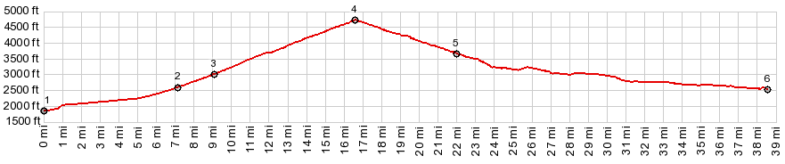
The first 1000 ft of climbing a contained in the
first view of the straight road heading to the
horizon. To the right Joshua Tree cactuses flank
the tire track shaped mountains of the Arizona
Strip. In the mid section of the climb, various
cacti species make great foreground for dessert
peaks in Arizona, Nevada and Utah. The road finally enters high rolling hills and
summits in series of rolling hills. Amazing to
think, that almost 3000ft were gained in this
gentle appearing climb without real turns.
From East. Soon after
the summit it becomes clear that the mountains on
this side have higher aims. The Pine Valley
Mountains straight ahead reach over 10 thousand
feet and an imposing series of cliffs, some topped
by lave leads up to them. The road crosses the
Shivwits reservation. There is one cheap gas
station. Otherwise at least the signs forbid acces
to everything else. The profile finishes in the
dessert suburban sprawl of Santa Clara, becoming
St George. The final town streets follow a signed
Sun River bike route.
Dayride with this point as highest summit: COMPLETELY PAVED ( < Smithsonian Butte Rd - Gooseberry Rd(sh) | Snow Canyon - Ut18(sh) > ) Ut91 Beaver Dam - St George Summit : near Black Range Road exit on I15, south of St George > I15 south > Beaver Dam > Ut91 north > Ut91 Beaver Dam - St George Summit > Shivwits > Santa Clara > St George > Pearl Rose Dr and others soutn > Dixie Dr south > I15 south back to starting point: 67.6miles with 3920ft of climbing in 5:11hrs (garmin etrex30 r4:19.10.19) Notes: the difference between the lowest point in St George and the highest point on I15, which is the Black Range Rd exit is just below 300ft. The worst part of this loop was I15 between Black Rd and about 10 before Beaver Dam. Shoulder is in very bad shape and often covered with some gravel. Otherwise this is a great loop A Ride with this point as intermediate summit is on page: Bulldog Pass Rd s(u) |
|
|
advertisement |
|
|
advertisement |