Ut130 Cedar City - Minersville Summit
This low, slightly curving
dessert summit is signed as a bike route.
It doesn't have a shoulder, but not much
traffic either, or rumble strips.
 |
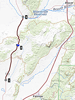
1.START-END
SOUTH:turnoff to Parowan Gap from
Ut130
2.TOP, 6580ft
3.START-END NORTH:jct Ut130 - Ut21,
Minersville
|
 Approaches Approaches
From South. This
starts out as a straight, long, barely
noticeable climb. To the east a sage plain
leads up distant Black Hills. Near the top
the hills become a parade of miniature
cones. A relay facility near the top is not
much higher than the summit. There is a
generic summit sign with elevation an no
name.
From
North. (described downwards) A long
sweeping turn or two lead into Minersville.
The top portion of this slope distinguishes
itself with the presence of a few trees,
highlighting neighborhood, dotting this
neighborhood of aunt hill shaped hills.
Dayride with this point as highest
summit:
COMPLETELY PAVED
( < Headlight
Pass | FR009
Pinto Crest s(u) > )
Ut130 Cedar City - Minersville Summit ,
I15 Beaver - Parowan s(u) : Parowan
Gap > Gap Rd west > Ut130 north >
Ut130 Cedar City - Minersville Summit >
Ut21 west > Beaver <> out and back
or road parallel and north of I15 to
turnaround where it turns into the hills
>> I15 north > I15 Beaver - Parowan
s(u) > 3800N Rd east > to
endpoint on 300E Rd south: 85.5miles with
3120ft of climbing in 6:19hrs (garmin
etrex30 r4:22.5.4)
Notes: I accepted a ride for the last 9
miles of this loop, after a double flat
that was difficult to fix on the road, due
to replacment tubes with too short valve
stems. People in this area are so
friendly, 3 cars had stopped to check on
me before I got a ride with a marshall.
Only unpaved section is the erroneous out
and back parallel to I15.
|
|
|
cLiCk on image ,
arrows , or thumbnails to advance
slideshow
|
|