< Left Panel   Utah Summits and Passes   Areas   Tables   Maps   All Favorites  
Main Panel:   Main Page   Map+Profile   Utah Map  


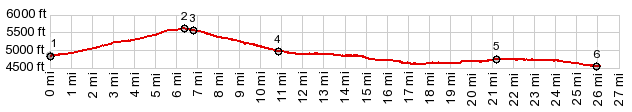
Headlight Pass

This is a low mountain gap in the Cricket Mountains. It is the easiest way to access Sevier Lake from the east side.

1.START-END EAST:jct Ut278 - Headlight Canyon Rd
2.TOP, Headlight Pass, 5640ft
3.jct between Headlight Canyon route and Headlight Gap on left
4.profile turns left onto Cricket Route 1
5.START-END WEST: jct Cricket Rte 1 - Black Rock Pass Rd
6.START-END WEST ALT:low point on Sevier Lake, on a spur road


Approaches

From East.
The turnoff from the paved road is signed as going to Headlight Canyon. It's a barely noticeably climb towards a lip of rocks to the north. In my case the most memorable thing have always been the strong winds. The road crests between two low ridges running north - south.


From West (described downwards). Soon after the summit of the pass, a turnoff to the right leads to higher points via Headlight Canyon. This route turns west and heads down towards a view of Sevier Lake. The lower part has two options, paralleling Sevier Lake in either direction - that is Cricket 1, the Shoreline Drive equivalent on Sevier Lake.


Dayride with this point as highest summit

PARTIALLY PAVED / UNPAVED

( < Headlight Canyon - Filmore Canyon s(u) | Ut130 Cedar City - Minersville Summit > )

Headlight Pass , Black Rock Pass : Cricket2, ~350ft below summit > Cricket1 west > Headlight Pass > Cricket4 west > Cricket1 south <> out and back on Black Rock - Garrison Rd west > turn around at end of a spur to a traffic shed on Sevier Lake >> Black Rock - Garrison Rd east > Black Rock Pass > Black Rock > back to starting point on Cricket2: 43.4miles with 2650ft of climbing in 4:47hrs (garmin etrex30 m3:22.4.28).
Notes: extremely windy afternoon


cLiCk on image , arrows , or thumbnails to advance slideshow


A Dayride with this point as intermediate summit is on page:  Headlight Canyon - Filmore Canyon s(u)


advertisement

advertisement