| |
| |
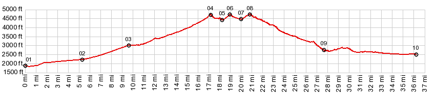
Saint George area: unmarked summit 01 s(u) An extensive web of gravel
roads, mostly on BLM land is accessible from a
trail head at the end of Navajo Drive in
suburban Saint George. The area around the
trailhead is designated as a "dessert
reserve", This is one of three very closely
spaced points, that can play the role of
highest summit in rough gravel day loops,
starting from the Navajo Drive trailhead. The
most prominent of these three summits is Bulldog
Road Pass summit in the Beaverdam
Mountains. For all practical purposes all
three summits are at an identilcal elevation.
There is a good chance that this one may be a
few feet higher than the other two.
Whichever option is chosen, They
all meet at a junction just slightly below 300ft
of this summit. There is actually a sign here,
the only one for many miles around. It only
offers hints of what might be in the southerly
direction: the Joshua Tree reserve. But the way to this summit heads
east. This road there can be seen when decending
from Bulldog Pass(sh). From there it makes a
surprisingly civilized impression, with guard
rails and a surface that might be paved. The
reality is gravel though. The road winds in a
few wild meanders to the top of a bare dessert
grass mound.
The route down takes the downhill
option at each junction, except for one at point
9. Here the downhill option goes to the shores
of West Mountain Valley Wash, which was a fairly
significant river during my visit in April 2023.
There is no bridge to the other side. Heading
back to the last junction and taking the
remaining option, the road further diverts from
the power line corridor, roughly followed so
far, and takes a more northerly course. It is
now a good fast surface and climbs again to
another low summit, before turning more easterly
again heading for the outskirts of the Saint
George. There is plethora of other roads close
to St George, but the way back is obvious. The
profile ends at a busy trailhead with all kinds
of motorized and unmotorized users.
Dayride with this point as
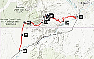
highest summit: PARTIALLY PAVED / UNPAVED ( < Beaverdam Mtns unmarked summit 01 s(u) | Nv158 Mt Charleston Loop s(u) > ) St George area: unmarked summit point01 , Bulldog Pass , BLM 1005 Beaver Dam Mtns , St George area: unmarked summit point02: partially up BLM1005 > up BLM 1005 > BLM1005 Beaver Dam Mtns s(u) > BLM 1005 north > Ut91 north > Bulldog Pass Rd east > Bulldog Pass > Bulldog Pass Rd(shp) > unmarked road heading east > following downhill option at every intersection[unsigned] << turnaround point at West Mountain Valley Wash > St George area: unmarked summit point02 > following options leading direction St George at every intersection > Dessert Reserve Th > Navajo Dr east > Manowar Dr east with detour > Pioneer Rd south > West Sun River Pkwy onto I15 > I15 south > Cedar Pocket exit > BLM1005 west back to starting point: 59.0miles with 6180ft of climbing in 7:21hrs (Garmin etrex32 m5:23.4.6) Notes: Thanks to Travis, who helped me find a speedy way through St George onto I15. The part on I15 was definitely unpleasant this time around. because of heavy traffic heading into the low sun and a sometimes extremely narrow shoulder. It is legal though. - There are three summit points on this loop in close succession. Due to the 300ft cutoff point (which I am arbitrarily using for these pages), the slightly lower Bulldog Pass becomes a summit point while the slightly higher Bulldog Pass(sh) is a shoulder point to this summit. St George area summit point02 is only a high point on this ride, if one takes (the wrong) turn down to the river (like me), instead of staying uphill on the left. |
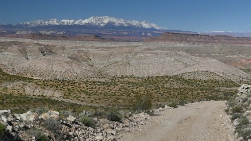 From East. (described
downwards). There are many intersections on the
way down, and none of them are signed. All of
the tracks are indicated as trails on my
somewhat dated openstreetmap product, even
though they are all well used gravel roads, a
bit steep and rocky in places. The only vehicle
I saw on the way down , before entering the
dessert reserve on the outskirts of Saint
George, was one other lone gravel biker. I think
he was working very hard on the way up. As
for me, a few places were borderline traction on
the way down, but all in all, very ridable,
rocky in a few places. On the way down, there
are unique views of this portion of the great
geological staircase, that is the transition of
Utah to Arizona, starting with light crumbly
badland shales on the bottom and terminating
with snow covered Pine Mountains under the
seemingly perpetual blue skies.
From East. (described
downwards). There are many intersections on the
way down, and none of them are signed. All of
the tracks are indicated as trails on my
somewhat dated openstreetmap product, even
though they are all well used gravel roads, a
bit steep and rocky in places. The only vehicle
I saw on the way down , before entering the
dessert reserve on the outskirts of Saint
George, was one other lone gravel biker. I think
he was working very hard on the way up. As
for me, a few places were borderline traction on
the way down, but all in all, very ridable,
rocky in a few places. On the way down, there
are unique views of this portion of the great
geological staircase, that is the transition of
Utah to Arizona, starting with light crumbly
badland shales on the bottom and terminating
with snow covered Pine Mountains under the
seemingly perpetual blue skies.|
|
advertisement |
|
|
advertisement |