| |
|
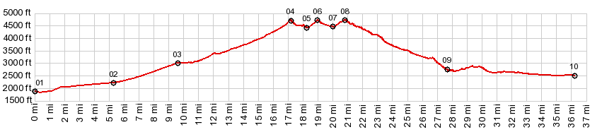
01.START-END SOUTH:jct I15 Beaverdam
exit
02.jct Ut91 - BLM1005
03.profile turns right onto Bulldog Pass Rd
04.Bulldog Pass, 4720ft
05.low point and jct to road leading lower, 4420ft
06.Bulldog Pass Rd s(u), 4730ft
07.low point and jct with road north to Ut91, 4470ft
08.St George area unmarked s(u)-1, 4740ft
09.jct on right with dead end road to West Valley Wash
10.START-END NORTH:Man O War Rd crosses West Valley
Wash in St George
|