| |
|
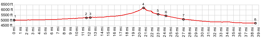
1.START-END EAST ALT:jct Ut199 - Ut36
2.jct Ut36 Faust Rd
3.START-END EAST: profile turns west onto Pony Express
Rd
4.TOP: Lookout Pass, 6192ft
5.jct with Hatch Ranch Rd on right
6.profile stays right at this fork
7.profile turns right onto Government Creek Rd
8.START-END WEST:jct with Ut199 at Dugway entrance
9.START-END WEST ALT: low point on Ut199 in Skull
Valley
|