| |
|
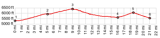
1.START-END WEST: jct Ut56 - Main St,
Newcastle
2.profile turns left onto Dessert Mound Rd
3.TOP:6400ft
4.low point on road, just before railroad crossing,
5600ft
5.Eight Mile Pass: 6040ft
6.profile turns right on Iron Springs Rd
7.START-END EAST: jct Iron Springs SRd - Ut56
|