| |
|
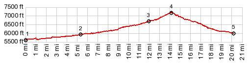
1.START-END EAST:jct US89 - Clear Creek
Canyon Rd at Marysvale Canyon Th
2.Clear Creek Canyon Rd separates from I70
3.jct FR114 - Clear Creek Canyon Rd
4.TOP. Clear Creek Canyon Summit, immdediate after
profile joins I70, 7180ft
5.START-END WEST:I70 exit 1, jct with Ut161
|