| |
| |
Confidence Mine s(u) The summit is small. But the views
are big ... because the valleys are big and wide
and stretch to the horizon. The highest point is
located just about exactly on the Utah - Nevada
line. I lean towards putting the summit into
Nevada. But the state boundary here does not
follow a ridgeline in an abvious way. So this
coincidence of being just about exactly on the
state line is very coincidental indeed. The mine
itself is safely located on the Nevada side
though. The surface on this ride is pretty good
for gravel biking, maybe a little sandy in
places.
But if you miss it all is not lost. Other turnoffs further north also get you there. Along the way, various sections of dead tree match stick forest are sandwiched between short sections of live juniper trees. All these approaches first go to something marked as Reed's Cabin Summit on my map. But there are no signs at any of the intersections or at the summit. But it is an obvious summit point with a decent into Nevada.
From South. (described downwards) A scenic roll down leads by a lonesome rock outcrop, surrounded by dead trees. It is an easily recognized landmark. Then a fast scenic decent leads to a memorial plaque. It tells the story of two firefighters who died in this area during a fire in 2012. The memorial stands in poignant isolation. To me this memorial comes completely unexpected. Its pictures and inscriptions remain in memory even more persistently than the landscape. The profile ends where the track rejoins the Hamlin Valley Rd.
Dayride with this point as
highest summit
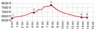
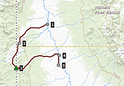
COMPLETELY UNPAVED: ( < Arrowhead Pass | Panaca Summit > ) Confidence Mine s(u) , additional out and back: starting at about 6400ft elev. on Modena Canyon Rd > Modena Canyon Rd north > Hamlin Valley Rd north > unmarked northern approach as above west > Reeds Cabin Summit(shp) > up unmarked road south > Confidence Mine s(u) > down eastern approach as above > Hamlin Valley Rd south > back to starting point on Modena Cayon Rd: 48.8miles with 3200ft of climbing in 5:18hrs (garmin etrex40 m3:21.5.14). 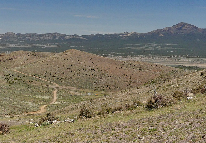 |
 At Reed's Cabin Summit
the profile takes a left turn-off, continuing
further up into the dessert hills. This road does
not show up on any of the map products on my
computer, but it does appear to be there on
satellite images. The first road gap comes into
sight above. Upon reaching it a second one appears
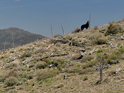
further above. In a dip between the two is a
curious spring, surrounded not only by heavy
construction equipment, but also various clans of
wild horses. The summit is a prime vantage point
over Hamlin Valley and the Indian Peak Mountains.
Looking back, the just traveled approach on the
road dwindles into nothingness in the scale of
this vast valley. The mine itself is safely
located in Nevada territory, even though the
entire approach was in Utah.
At Reed's Cabin Summit
the profile takes a left turn-off, continuing
further up into the dessert hills. This road does
not show up on any of the map products on my
computer, but it does appear to be there on
satellite images. The first road gap comes into
sight above. Upon reaching it a second one appears
further above. In a dip between the two is a
curious spring, surrounded not only by heavy
construction equipment, but also various clans of
wild horses. The summit is a prime vantage point
over Hamlin Valley and the Indian Peak Mountains.
Looking back, the just traveled approach on the
road dwindles into nothingness in the scale of
this vast valley. The mine itself is safely
located in Nevada territory, even though the
entire approach was in Utah. |
|
advertisement |
|
|
advertisement |