| |
| |
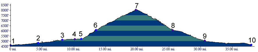
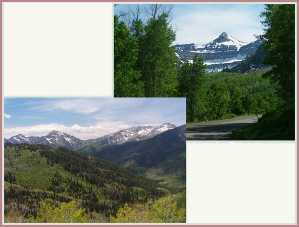
Alpine Loop Road Summit
 The
Alpine Loop Road Summit just may be the best
alpine paved climb in Utah. At least it was for me
during a day in May, when the road was still
closed to automobiles, but open to nonmotorized
traffic. The
Alpine Loop Road Summit just may be the best
alpine paved climb in Utah. At least it was for me
during a day in May, when the road was still
closed to automobiles, but open to nonmotorized
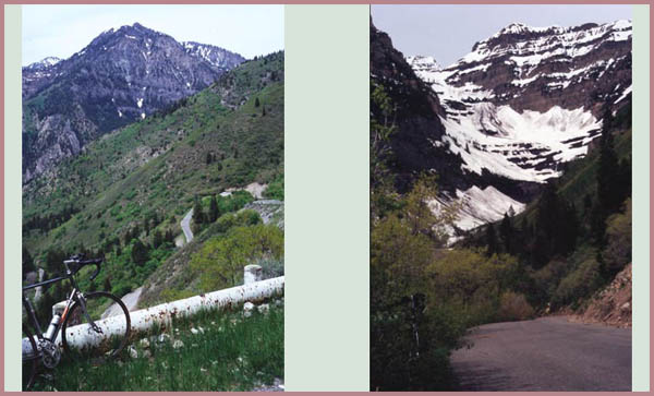
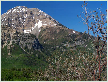
traffic.The tight, narrow turns on the western side are something special for this continent, where highways usually cut across all obstacles like a knife. Instead this is a narrow thread of a road, winding itself up a shoulder of majestic Mount Timpanogos, and climbing to a hap at just about treeline. I don't know how heavy the summer traffic is, which would seriously detract from the cycling suitability. The pass is indicated as summit on some commercial maps. There is no summit sign.
Approaches
From South West. The approach from Provo
starts with the best part of Provo Canyon, an
excellent bike path far from traffic. After a
short section on the shoulder Ut92 turns up to the
Sundance Ski area. The place is worth a stop to
view interesting photography centered around
celebreties of cultural events at Sundance,
naturally including Robert Redford.
From South. A parking area at the summit
gives the opportunity to study a map of the
Wasatch Crest Trail which crosses here from Pole Line Pass
on its way up the monumental Mount Timpanogos. The
initial switch backs give the impression of being
on a narrow mountain pass, somwhere in the alps.
Following that, American Fork Canyon shows a deep,
spectacular side, the likes of which only exist in
northern Utah. The lower road is a much straighter
and faster decent than the other side. Other approaches. The Cascade Springs
forest road offers another way to the summit from
the east. It joins the southern approach almost at
the top. It is paved at least from the Cascade
Springs area. This is more of a conventionally
engineered road with wide sweeping turns instead
of the made-for-bicycle minuature road features of
Ut92. From Cascade Springs a short cut dirt road
leads directly into Midway, entering the town
behind the golf course. One advantage of the
Cascade Springs approach is that it bypasses the
worst part of Provo Canyon, which is currently
under construction (2006).
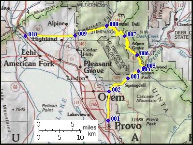
Dayrides. A loop ride from Midway over Pole Line Pass,
down American Fork Canyon to its junction with the
Alpine Loop Road, then returning over this summit
and the Cascade Springs road, also using the
described shortcut to Midway, measured 65 miles
with 7270 feet of climbing in 6.5 hours using a
Cateye 100AT computer (m3:6.6.3) A loop ride starting at the Alpine Summit to the
TR157
summit: Ridge Trail, over Sandy Baker Pass
to Pole Line Pass,
down to Cascade Springs and back to the starting
point via the Cascade Springs Road measured 31
miles with 5200ft of climbing over 5:1 hours,
using a VDO MC1.0 cycle computer (m3:07.06.02).
This also includes about 5 miles and 400ft of
additional approach to the loop from the
Salamander Flats area.
back to
cycling Utah's summits and passes |
|||||||||||||||||||||||||||||||||||||||||||||
|
|
advertisement |
|
|
advertisement |