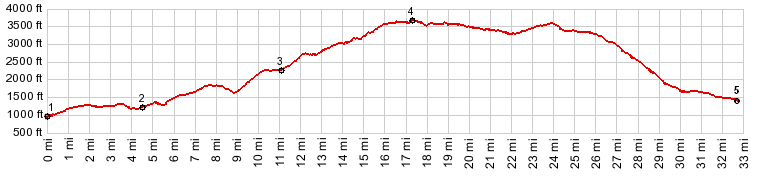
| |
| |
FR16 Vista Ridge Road
s(u)
When I read the sign: "Vista
Ridge Road", I didn't really expect very much.
I expected that the vistas would continue to
be what I had seen so far, power lines and the
haphazard patterns, left by the timber
industry leaves after it clear cuts the
forest, in order to provide raw materials for
millions of american card board houses. But I
was wrong, there is a variety of vistas of two
volcanoes to be seen, Mount Hood mostly to the
north, and quite a bit further away - Mount
Saint Helens in Washington. For foreground you
have a choice of aforementioned clear cut
patterns, powerlines, and also a few rare
views of a narrow road traversing an
unspoiled, rarely visited forest. There are
higher summits in this area. But from the ones
I have been able to ride, this one is the most
interesting - and completely paved with little
to no traffic. (I only say "little" instead of
"no", because somebody might actually
encounter a car)
From West. FR18 connects Lolo Pass with
the Columbia Gorge. The road has a well signed
turnoff onto FR16, climbing steeply to the south
on a nicely paved road, even if my de Lorme
Gazetteer has not the slightest indication that
this road exists. Describing the situation, coming
from the other side, that is coming down from Lolo Pass:
After riding through all the clear cuts, north
of the pass, seeing some real forest next to the
road is a relief. After a substantial climbing
workout on FR16, a vista of Mount Hood appears
to the north, followed shortly by an equally
stunning volcano vista to the south. Unlike the
more traveled highways, there is no effort here
to preserve the illusion that this is unspoiled
forest land. The piles of haphazard decaying
lumber left to rot next to the road, are in a
way just as dramatic as the snow covered
volcanoes - but in a very different way. Mixing
all these vistas, sometimes the same volcano
appears in front of the road, then as a
backdrop, the opposite direction where it just
appeared to be, which is proof that this road is
not the shortest connection between two points,
but really winds around like a snake on acid.
It's impossible to tell exactly where the top on
this long rolling ridge ramble is. From East. But sooner or
later a long straight descend leads into a fast
ride to Parkdale. Mount Saint Helens makes a few
last scenic backdrop appearances. The valley
below looks like a giant ski resort in the
summer, the clear cuts playing the part of the
ski runs. A large mass of black lava flow
ornaments the valley. The roll ends very
civilized, as the road passes between fragrant
plantations of fruit trees and grapes. Parkdale
has a single expensive grocery store and few
nice picnic tables near the museum
Vista Ridge Road: spectatcular
Volcano views alternate with logging
devastation. More pictures of just the volcano
without the devastation are in the short slide
show below
- |
 Approaches


|
|
advertisement |
|
|
advertisement |