| |
| |
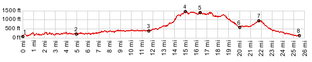
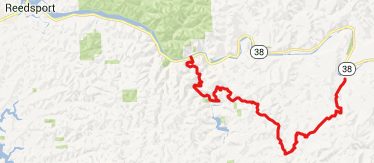
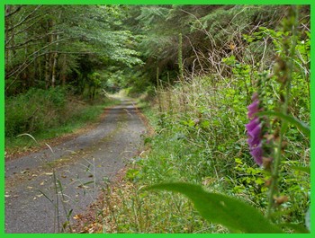
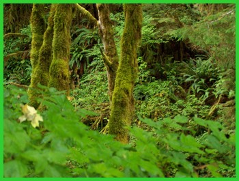
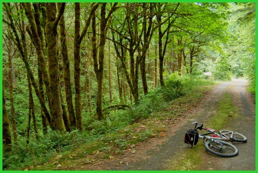
Buck Creek Road/ Lindy Bridge Road s(u) The Oregon Coastal forest is an amazing sight. I now have a whole photo series just of moss covered trees spanning small streams, slowly trickling along, far removed from sunlight. But the most surprising thing to me about this route is still the fact, that the entire road surface of the profile below is paved, and at the same time cars are an endangered species on this road. But we don't need to worry, there are still plenty wild cars roaming neaby Or38 along the Umpqua River. - All pictures on this page are taken on section between points 3 and 6.
From North. The profile
starts at the jct of Loon Lake (or Mill Creek)
Road with Or38. This is upstream on the Umpqua
River from Reedsport. Compared with Or38, this is
the first of several turnoffs that leave behind
traffic, until it's all gone completely. The next
turnoff to the left onto Camp Creek road further
cuts donw on traffic. On Camp Creek Road there still may
be the occasional car. Next the profile takes the
first paved turnoff to the right over a bridge.
There are no signs at the junction, but when a
sign appears signaling trees planted by Lower
Umpqua schoolchildren, the turnoff is near. The
route continues over a narrow one lane road. This
could be a bike path somewhere. But this is an
actual road, perfect for a road bike with sturdy
tires. After all this thick forest riding
following streams embedded in mossy growth -
surprise - this Buck Creek Road climbs after all.
Another sign appears, boasting another Douglas Fir
grove planted by Umpqua school children. The
biggest attraction along this road are the
isolated patches of old growth, mossy forest. They
make a virtual spider's web on the space above the
earth surface. Another sign corroborating that
this is the right way appears. It labels another
fork of Buck Creek, turning off to the left. ( I
think prior to this is another BLM number signed
fork, where I stayed left) For the finale the road
really shows how it can climb. It made me walk.
The road reaches the highest altitude just prior
to the signed Soup Creek Road turnoff to the
right. From South. (described
downwards). After a miniscule descent, the road
climbs again to within 30ft of the summit. Here
another paved road entering from the right soon
turns to dirt. Staying left the profile continues
on what is signed as Lindy Bridge Road. According
to the map this point is pretty much the same
elevation as the summit, but measuring it with a
altimeter it was slightly lower. A fast descend on
a wider road leads to a simple bridge, still it's
a new vantage point onto these grown over creeks.
To orient oneself it's best to start by observing
which way the stream is running, then follow the
road upstream and look for yet another
intersection a few yards away. Here are signs that
label both directions of Camp Creek Road and
Little Camp Creek Road. The profile climbs Little
Camp Creek Road s(u) and then descends past the
jct with Bridge Rd to Henderer Road back on the
Umpqua River.
Dayrides. PARTIALLY PAVED / UNPAVED: ( < SFR7000
Schofield Ridge Road | BLM 23-8-28:
Elliot State Forest s(u) > ) - |
||||||||||||||||||||||||||||||||
 Approaches
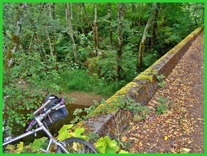
|
|
advertisement |
|
|
advertisement |