| |
| |
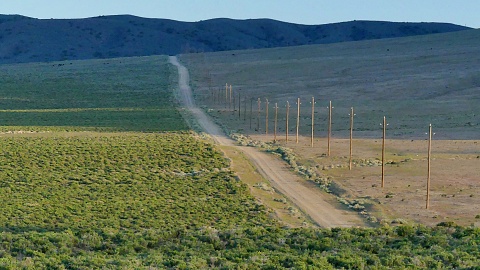
Earthquake Faults Rd s(u)
I have no idea if this is the real official name of the road. But there are no other signs, and my maps don't have any additional labels either. Maybe it doesn't have a name. But it goes over a low flank alongside Fairview Mtn. You can also see a road track to
the top of Fairview Mountain. But the prospect
of a bikable route all the way to the top of
Fairview Mtn is not realized. Instead the trek
over the gentle dirt road summit next to the
peak is a ultimately enjoyable experience in
scenic desolation, with an uncommonly bike
friendly surface. - Great loop
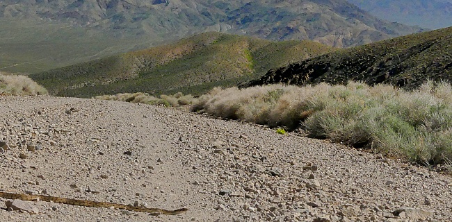
At the top an unsigned road leads up
to the microwave facility on Fairview Mtn. After
the Fairview Mtn road exits the debris field near
the turnoff and starts climbing the actual ridge,
it becomes abundantly clear that this track is not
ridable - at least not by anybody sane. It makes a
nice hike anyway and I included a few pictures
from this
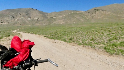
From South. (described
downwards) This main road however remains very
bike friendly and a short ,gentle decent can be
enjoyed at full speed. The desolation of the
gentle mountain bowl on the south side is
inspiring. The profile aims to get back to paved
Nv 361, and it does so by taking a left at every
heavily used intersection. This leads over another
gentle rim, that is not large enough to be counted
as a summit. Past that it leads through a small
ravine flanked by in a few places by rocks
resembling portal gates. Eventually it meets the
pavement of Nv361.
Slideshow of the two way bike
summit
Dayride with this point as
highest summit
( < Sand Springs Pass| Carroll Summit > ) Earthquake Faults Rd s(u) , Nv361 Middle Gate s(u) : a short distance up Earthquake Faults Rd > up Earthquake Faults Rd <> out and back partially up Fairview Mtn with turnaround point at 6880ft >> down north side of Earthquake Faults Rd > first major road on left as shown in profile > Nv361 north > Nv361 Middle Gate s(u) > US50 east > back to starting point on Earthquake Faults Rd :41.4miles with 3100ft of climbing in 4:26hrs (garmin etrex e32 m5:23.05.18) Notes: day also included a hike up dirt track to first peak on Fairview Mtn: b+h: 44.3miles with 4370ft of climbing in 5:38hrs). - Hottest day sofar. Slideshow of the hike to the top of Fairview Mtn
|
 This
name may sound familiar, if you have traveled on
US50 between Fallon and Austin. One of the very
few signs along the road indicates "Earthquake
Faults", that way.
This
name may sound familiar, if you have traveled on
US50 between Fallon and Austin. One of the very
few signs along the road indicates "Earthquake
Faults", that way.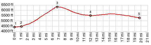
|
|
advertisement |
|
|
advertisement |