| |
| |
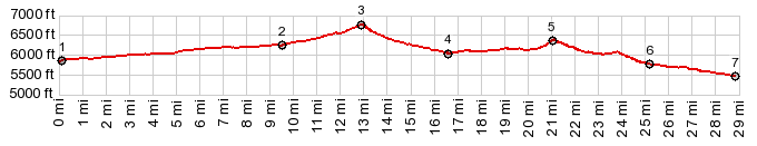
Meloy Summit
This is a small pass, south of
Pioche, that is marked on the de Lorme Gazeteer as
a dashed line, usually reserved for jeep trails or
the like. In spite of this, the surface is better
for cycling than dirt roads marked with through
going lines.
From West. (described
downwards). The ranges to the west of here have
more interesting topographies and they first come
into view soon after the summit: Schell Creek
Range, the Egan Range, and others flow away to the
west like waves whipped up by the wind.
Approaching the valley, there are good bikable
dirt tracks in all directions. None of the
intersection are signed. But orientation with
respect to the mountain ranges that always run
north - south is not so difficult. There are also
sometimes signs for the Nevada Silver State OHV
trail. The profile follows these signs along the
valley south, crossing another summit between
areas approaching Robinson Spring and Fence
Spring. A reference for the future and myself:
From the map it appears that it is possible to go
lower in a more direct fashion direction Big Mud
Pass.
Dayride with this point as highest summit: PARTIALLY PAVED / UNPAVED ( < Pioche s(u) | Patterson Pass > ) Meloy Summit , Unmarked BLM road Robinson Spring - Fence Spring s(u) : near Jct US93 - Mallory Rd > Mallory Rd west > Meloy Summit > unmarked BLM road south passing near Littlefield Spring > Robinson Spring > unmarked BLM Rd Robinson Spring - Fence Spring s(u) > Bristol Wells > Bristol Pass(shp) > US93 north back to starting point along Mallory Rd: 38.5milew with 2420ft of climbing in 3:37hrs (garmin etrex30 m3:19.11.8). Notes: Bristol Pass is always a shoulder point. It doesn't have 500ft elevation gain on the east side, regardless of where you start. |
|
|
advertisement |
|
|
advertisement |