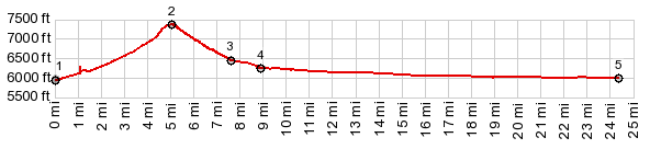
Mountain pass roads in this part
of Nevada generally do not have a huge elevation
gain. But views reach so far in every
conceivable direction in this bare and pristine
landscape, so that the size of the landscape
itself becomes the controlling factor of how
"big" the pass feels. At the end of the day I am
always surprised that the total climbing
elevation was fairly small. Patterson Pass is
actually one of the higher passes in the series
of ranges running south of Nv316 (I cannot find
a higher one, that is not a sandy jeep trail).
It passes between structurally beautiful Mount
Grafton (10080ft) and the lower northern end of
the Schell Range.
The profile starts at this dirt road turnoff, and
continues in a fairly straight line up towards the
pass. The last section before the pass contains a
very steep section. The top is in a needle forest
and tracks seem to leave from both sides of the
road, making it tempting to climb either of these
two wild looking peaks on foot. There is also a
BLM sign naming the pass with elevation, a rarity
in Nevada.
From West. (described
downwards) The road continues in the same style of
wide, industrial strength gravel road. Progress is
fast, and there is really no washboard surface. At
the bottom the cliffs of Mount Grafton come into
even better perspective. Here is a prominent, well
signed intersection, another Nevada rarity. Signed
destinations include Shingle Pass, Sidehill Pass
(always a shoulder point), and other points in the
wild and varied Cave Valley. The mountains
limiting the west side of the valley have a
completely different appearance from Mount
Grafton.
Dayride with this point as highest summit: PARTIALLY UNPAVED / PAVED ( < Meloy Summit | Wheeler Peak Scenic Dr(ow) > ) Patterson Pass , Kixmiller Summit : Patterson Pass Trailhead > Patterson Pass Rd west > Patterson Pass > South Cave Valley Rd south > Sidehill Summit(shp) > Kixmiller Summit > US93 north > back to starting point at Patterson Pass Trailhead: 56.6miles with 2710ft of climbing in 5:05hrs (garmin etrex30 m3:19.11.9) Notes: the only sign of life, that I encountered on the unpaved section starting at the trailhead was birds and two wild horses galloping across the road at full speed. |