| |
|
|
|
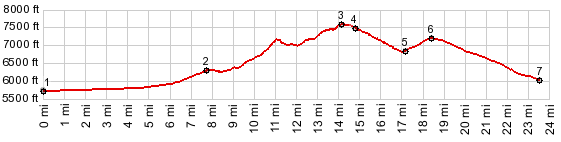
1.(5730ft,mile00.0)START-END WEST ALT: jct US50 - Old Overland Road
2.(6320ft,mile07.7)profile turns left onto paved road, immediately after the jct with Nv305
3.(7600ft,mile14.1)TOP: highest point on Emigrant Pass Road
4.(7484ft,mile14.3) Austin Summit; profile turns left and follow US50
4.(6840ft,mile14.8)Grass Valley Rd takes off on left
5.(7267ft,mile17.1)Bob Scott Summit
6.(6840ft,mile18.3)START-END EAST: Grass Valley Rd takes off on left
7.(6070ft,mile23.3)START-END EAST ALT: jct with Nv376 on left
|