| |
|
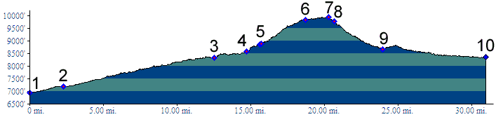
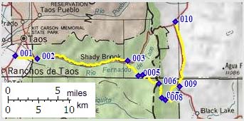
01.(mile00,6940ft) START-END WEST ALT: jct
NM585-NM68, just south of Taos.
02.(mile03,7190ft) jct NM585-US64, just west of Taos.
03.(mile13,8330ft) START-END WEST: profile branches right onto FR437 to Valle Escondido
04.(mile15,8580ft) route turns left uphill onto FR70. Profile is indistinct to next point.
05.(mile16,8860ft) join FR70A
06.(mile19,9830ft) Osha Pass
07.(mile21,9940ft) TOP: point of highest altitude
08.(mile21,9780ft) join FR76 and continue downhill on left
09.(mile25,8680ft) START-END EAST: profile joins paved NM434 and turns left
to Aqua Fria
10.(mile31,8360ft) START-END EAST ALT: jct NM434-Palo Flechado Pass in Aqua Fria.