| |
| |
This is an old historic Lookout
above West Pass, off US60 east of Pie Town. It
has great distant views onto the Sawtooth
Mountains, a a rugged series of outcrops
appreciated not only by rock climbers. The
GDMBR takes dead aim at the Sawtooth Mountains
on a long straight trek through the dessert,
when heading for Pie Town. .And the it
actually bypasses it.
The next turnoff onto the jeep
trail to the lookout tower is also signed. There
is also an old historic school house here
according to the signs. I'm not sure if I
believe that, but there are a few structures of
variable integrity, with one of them decked out
as an investment tool. These last two miles to
the top included a lot of walking for me. But
it's all a workout, and the views on top are
fairly incredible, stretching from the rocky
Sawtooth Mountains behind Pie Town to various
mystery ranges, shrouding themselves into
increasing haze direction Arizona. The small
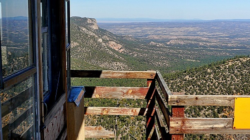
historic lookout tower is flanked by two modern
microwave relay stations. The tower is low, but
you can climb it and marvel through the windows
at the interior, including a historic Fire
Lookout Register, a stove for cooking and other
kitchen utilities to keep you from getting too
hungry while keeping a lookout for smoke in the
distance. From East.
(described downwards). This side is barely
traveled now, since at the time of writing the
access to the forest road from the bottom is
blocked by a locked gate. A microwave service
technician who just happened to be servicing
something in one of the towers at the top
however, told me that the owner of the blocked
entrance was a very nice person and that with a
bicycle there shouldn't be a problem. There
wasn't.
Dayride with this point as
highest summit
PARTIALLY PAVED / UNPAVED (< FR239 Lobo Canyon s(u) | Az261 White Mtn Rd s(u) > ) Davenport Lookout Tower s(u) , FR6A Sawtooth Mtns s(u) : near jct FR6A - US60 > US60 east > FR6 Davenport Canyon north > Davenport Lookout Tower s(u) > down Thompson Canyon > US60 west > back to starting point near jct FR6A - US60 <> separate out and back <> FR6A north <> FR6A Sawtooth Mountains s(u) << turnaround point on US6A in WH Canyon at ~7200ft: 54.8miles with 3570ft of climbing in 6:05hrs (garmin etrex32x m6:24.10.26) Notes: the out and back on FR6A was planned as a loop over Pie Town. But the turnoff heading east from FR6A was too dubious. - Amazingly warm / hot day for end of October. 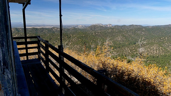 |

 The first two miles
down are at least as rocky as the last two miles
up. After that the dirt/rock road is 98 percent
rideable without doing circus tricks, which are
not in my repertoire. Thompson Canyon has a few
fanciful, interesting rock outcrops. The road is
clearly marked with a forest service road number
before it enters the last section which seems to
parallel private land. Coming from the other
direction the turnoff can be recognized by
a road that is visible across a meadow and
various "private road statements".
The first two miles
down are at least as rocky as the last two miles
up. After that the dirt/rock road is 98 percent
rideable without doing circus tricks, which are
not in my repertoire. Thompson Canyon has a few
fanciful, interesting rock outcrops. The road is
clearly marked with a forest service road number
before it enters the last section which seems to
parallel private land. Coming from the other
direction the turnoff can be recognized by
a road that is visible across a meadow and
various "private road statements".|
|
advertisement |
|
|
advertisement |