| |
| |
The New Mexico town Grants is
famous for being on the historic Route 66. But
I think, it should be much more famous for the
presence of Mount Taylor, topping out at
11300ft, within comfortable cycling distance
of the town. However, no road goes to the top,
although a variation of the route described
here, reaches a Lookout tower 300ft below the
summit. The FR239 route tops out on the
verdant green and gentle slopes of Mount
Taylor. It is also a summit on the Great
Divide Mountain Bike Touring Route.
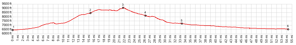
Heading out on a wide paved road
with a huge shoulder designated for bicycles,
Mount Taylor looms ahead, its gentle triangle,
lined in light green, signifying a meadow above
treeline. That will have been the best view of
the highest mountain in Cebolla National Forest
for this ride. The road heads up towards two
mesas with mining scars. A gentle decent and the
paved road seems to head for a saddle promising
a new view on the other side, while the two
mining mesas now appear at eye level and
relatively unscraped. But this is just the first
of many saddles that appear as tops, but really
aren't. Some more gentle climbing and the
next apparent top appears. Here the pavement
ends, the forest finally stand stays around, and
there is also the first intersection with a road
to the La Mosca Lookout tower. But this profile
forsakes the promise of far views and stays on
the main road, which is now designated FR239. A
deep gravel gives way to a smoother more bike
friendly surface after a couple of miles. But
the endless forest surroundings are here to
stay. It feels like we have gone over the top
already. But there is always an unexpected
roller that goes just a little higher. The road
passes a second signed turnoff to La Mosca
Lookout. Next: a gently descend with many more
curves than went before, passes yet another
signed turnoff to La Mosca. Next comes the
signed San Mateo Spring. The road changes
direction radically towards the west. A short
slightly steeper and rougher climb leads to the
true summit. From here you can spy the canyons
of the San Lucas Valley between the trees for
the first time 
From North.
(described downwards) Now the road is as
straight as it was curvy just five minutes ago
on the other side. A potentially lightning fast
decent leads through the trees heading north. At
the next junction the profile says goodbye to
FR239 and also the GDMBR route. Instead it
descends further on FR456 in an easterly
direction. For me personally this next section
is actually the most scenic. The road seems to
head towards a canyon and mesa landscape in the
San Lucas Valley. But it never gets there and
instead diverts to suburban looking San Mateo.
The next two intersections, until the route is
back on NM605 are fairly obscure to recognize
when looking for this route in the opposite
direction. When traversing the route in the
opposite direction, the first required unsigned
left from one paved road onto another, features
a traffic triangle with a tree on it. After that
the first right onto an unpaved road can be
recognized by the presence of private mining
sign. The profile includes the long gentle
decent on NM605 to its junction with NM122.
Dayride with this point as
highest summit
( < CR520 Delgatito Mesa | Davenport Lookout(ow) > ) FR239 Lobo Canyon s(u) : a short distance past National Forest boundary on NM547 > up NM547 > FR239 Lobo Canyon s(u) > down FR453 > NM605 south west > Milan > NM122 south east > Grants with sightseeing detours > NM547 north back to starting point: 61.4miles with 3430ft of climbing in 5:52hrs (garmin etrex32x m6:24.10.24) Notes: headwind, when heading back in south direction, amazingly big temperature difference between a cool morning and hot finish. |
|
|
advertisement |
|
|
advertisement |