| |
| |
Az261 White Mountain Rd s(u) The "White Mountain Scenic Road"
actually consists of two separately numbered
state roads, that climb a relatively high lava
plateau in the White Mountains. This is
fantastic road biking territory because of
very little traffic (at least in my experience
in late October) and roads so smooth, you
might think you are in Europe somewhere. The
two roads each have a high point, but the
elevation difference between the low point and
the two tops is less than 300ft, But yet
another paved road climbing onto this lava
plateau meets between these two summit points
and thus Az261 and Az273 have separate summit
points (while the 3rd approach by itself does
not).. This one is slightly lower than its
counterpart on Az273.
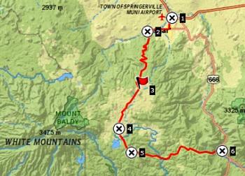
"Big Lake Junction" figures
prominently on signs. It seems to me, that there
are at least 3 junctions in this area, that this
applies to. At this particular one, the climbing
really starts. Big Lake is a ubiquitos goal for
great cycling routes in this part of Arizona.
After a thousand feet of climbing, the first far
views onto swarms of shallow cinder cones appear
on the high dessert floor towards the north. It
becomes obvious, that the White Mountains are
not only a large lava capped mesa, but it
surrounding valleys also include swarms of these
circular hills. They give the landscape below a
repeated pattern, that seems to go on to the
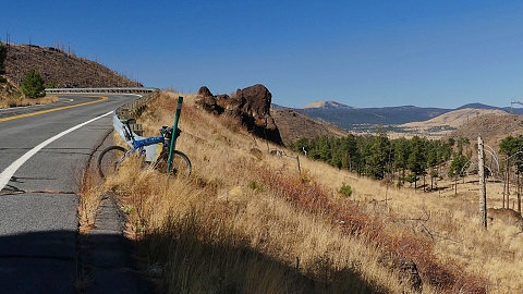
horizon. Soon the first lava caprocks appear,
crowned by needle trees with ample space between
them. In spite of the climbing Springerville
seems more far away than far below.
Surprisingly, we have already climbed more than
half of the elevation, at the point where a
formal viewpoint "Point of the Mountains" points
out the names of the various cinder cones in the
distance. From here it is goodbye rocky rim,
hello needly forest. But this too passes, where
the road breaks out into an almost prarie like,
rolling grass-scape and crests a shallow summit.
And since this page is about
making Az261 the summit (instead of Az273),
the profile stays left at this T junction, and
continues past Crescent Lake and Big Lake in the
distance. This state road becomes a National
Forest Road and surprisingly remains paved all
the way through to Alpine. Other gravel options
exist to make the loop back towards the northern
approach a little shorter. One of them was my
dayride below and is shown in the profile. There
is a link to a komoot page (with map and more)
at the bottom of the page.
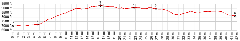
Dayride with this point as
highest summit
PARTIALLY PAVED / UNPAVED ( < Davenport Lookout s(u) | Az273 White Mtn Rd s(u) > ) Az261 White Mountain Rd s(u) : near several miles up Az261 from its jct with Az260 <> couple of miles out and back and return because of having to fix the derailleur >> up Az261 > Az261 White Mtn Rd s(u) > FR285 east > FR88 east > Nutrioso > Az180 north > Springerville <> several mile of out and back on US180 to a short distance after its jct with US60 due to missing a turn >> Eagar > Az280 west > back to starting point on Az261 : 72.7miles with 4790ft of climbing in 7:07hrs (garmin etrex32x m6:24.10.30) Notes: one of the arms on the rear derauiller cage broke during the first mile of climbing. Sofar its fixed by taping a nut between the supporting arms with duct tape and reinforcing it with two zip ties. It held. Return just when it was getting dark. |
 From South. (described
downwards). There is a large variety of routes
to choose from on the way down. Many involve
good gravel roads. The first of them appears
just a short distance past the summit. After an
extended joyride on the grassy rollers, you
reach a T junction. Going right here continues
the scenic journey on the White Mountain Road,
For that option the actual summit is still
ahead, only about 100ft higher than the point
described on this page. The dip between the two
is only about 200ft.
From South. (described
downwards). There is a large variety of routes
to choose from on the way down. Many involve
good gravel roads. The first of them appears
just a short distance past the summit. After an
extended joyride on the grassy rollers, you
reach a T junction. Going right here continues
the scenic journey on the White Mountain Road,
For that option the actual summit is still
ahead, only about 100ft higher than the point
described on this page. The dip between the two
is only about 200ft.|
|
advertisement |
|
|
advertisement |