| |
| |
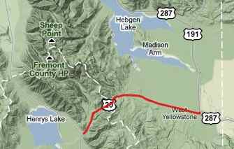
Targhee Pass
 Nearby
Raynold's Pass was first named "Low Pass". There
are a number of passes on the southern part of the
Idaho Montana border that deserve this name, but
maybe none more so than Targhee Pass. The road
carries heavy tourist traffic to Yellowstone Park.
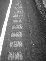
It has a good shoulder on the Idaho side, but the
shoulder is rumble stripped in a very disagreeable
manner on the Montana side (not quite as bad on
the Idaho side), making this a potentially
dangerous route for bicycles during Yellowstone
travel season. Nearby
Raynold's Pass was first named "Low Pass". There
are a number of passes on the southern part of the
Idaho Montana border that deserve this name, but
maybe none more so than Targhee Pass. The road
carries heavy tourist traffic to Yellowstone Park.
It has a good shoulder on the Idaho side, but the
shoulder is rumble stripped in a very disagreeable
manner on the Montana side (not quite as bad on
the Idaho side), making this a potentially
dangerous route for bicycles during Yellowstone
travel season.
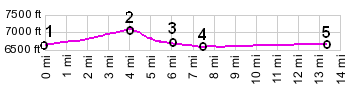
From North. It's a quick 200ft ride to the
top. As the short ascent begins Targhee Peak at
10180ft enters the picture for a few hundred
yards. There are no pass or elevation signs at the
top, but the name shows up on practically all
state maps. From South. The shoulder
disappears and the heavy traffic remains as the
road aims in a utilitarian straight route to the
town of West Yellowstone.
Dayrides with this point as highest summit: PARTIALLY PAVED / UNPAVED Targhee Pass , Raynolds
Pass: near jct Targhee Trail forest
road - US20 > Targhee Pass > West
Yellowstone with 5 to 10 miles of sightseeing
detours > US287 north and west > Hebgen Dam
> Raynolds Pass > back to starting point: 75
miles with 2500ft of climbing in 5:3 hours. ( < Hyalite
Canyon(ow) | Green Canyon
Pass > ) same summit points: ~1.4miles up Teepee Creek Rd
from jct US191 - Teepee Creek Rd > down Teepee
Creek Rd > US191 south > US287 west >
Mo87 south > Raynolds Pass > US20 east >
Targee Pass > West Yellowstone > US191 north
> back to starting point on Teepee Creek Rd :
69.7miles with 3010ft of climbing in 5:23hrs
(garmin etrex30 r4:20.8.28) The fur trade. The Indian trail that ran
over this pass from Snake River country to the
Gallatin Valley became known to trappers with the
discovery of nearby Raynold's Pass by Andrew Henry
in 1810. When they referred to crossing North Pass
it could mean either going across Targhee or Raynold's Pass. Chief Joseph and the Nez Perce. The
government had designated a forever-homeland for
the Nez Perce Indians in Wallowa Valley, eastern
Oregon in 1855. However, forever is a strong term,
and sometimes (or maybe always) forever doesn't
mean forever. When Chief Joseph refused to move
his band into Idaho the government responded with
force in 1877. The resulting flight and ensuing
battles moved across today's Montana into
Yellowstone. Today numerous road signs in the area
remind of the flight of 700 people. Amongst the
areas crossed is also Targhee Pass. After the
battle at today's Big Hole Battlefield the band
crossed Medicine Lodge Pass and then approached
Targhee Pass via Centennial Valley. Their route
continued into Yellowstone Park heading towards
today's Dead Indian Pass. back to Montana's passes and summits by bicycle |
 Approaches
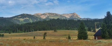 History