| |
| |
Green Canyon Pass If West Yellowstone is a
Yellowstone National Park city, Island
Park are the National Park suburbs. An
array of unpaved roads thread together
large retirement homes, growing between
the farmlands and sage. On the west side
are the Pioneer Mountains, running
contrary to the general geological rule of
the west. They run in an east west
direction. The GDMBR route is on the other
side of the Centennial Mtns, where the
fault line is much steeper. Green Canyon
Pass starts in Island Park and then climbs
through a small forested hill, south of
the valley. The name is not used on any
signs in the area. It is used in the
deLorme Gazeteer maps.
The Green Canyon Rd heading
south, reaches a low point and the profile
starts there. Soon it's goodbye views, hello
trees. Only at the summit can you catch a
glimpse through the trees of the reservoir
below and the great breadloafs of the
Pioneer Mtns
From
South. A single clearing shows a
forested plain ahead to the south. This
could be Minnesota at 6000ft, but it is not.
The road merges onto busy US20, much of
which would be a nightmare on a bicycle.
But, accepting much slower progress, its
possible to ride snowmobile and ATV trails
on its side. 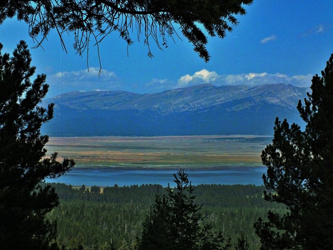
Dayride with this point
as highest summit:
PARTIALLY PAVED / UNPAVED ( < Targhee Pass | Sawtell Peak Rd(ow) > ) Green Canyon Rd s(u): Stamp Meadow Rd, 1.3 miles from jct Yale - Kilgore Rd-Stamp Meadow Rd > Stamp Meadow Rd south > Old Shotgun Rd west > Green Canyon Rd south > Green Canyon Pass > Green Canyon Rd east > snowmobile trails paralelling US20 north > old Id191 north > Island Park Res with detours > Philips Loop Rd north > Yale - Kilgotr Rd west > back to starting point on Stamp Meadow Rd: 47.4miles with 1780ft of climbing in 4:17hrs (garmin etrex30 m3:20.8.30) Notes: US20 to complete the loop is another rumble strip terror highway, full of vacation depraved Yellowstone maniacs, making this road worse than any potential Long Island expressway experience. Luckily it can be avoided with snowmobile trails and other rough roads. It makes sense that the GDMBR was conceived in an area where so many paved roads are not really bikable (neighboring state though) First ride with good temperatures since June. |

|
|
advertisement |
|
|
advertisement |