| |
| |
Flathead Pass The two approaches to this
low crossing in the Bridger Range are
opposites of one another in every aspect.
I like the eastern side better.
 Approaches 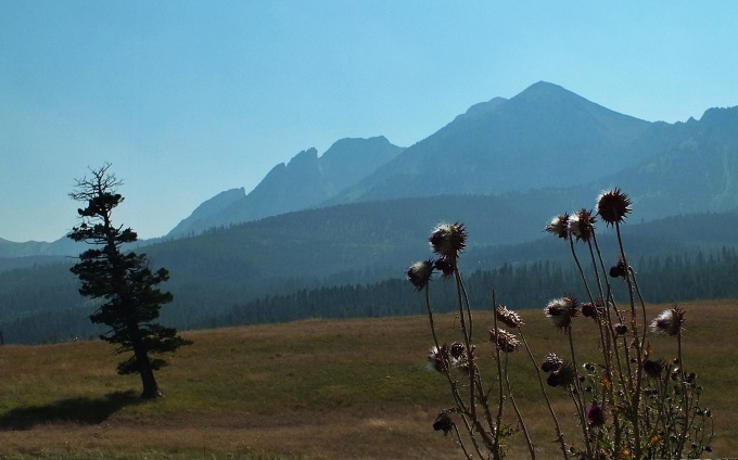
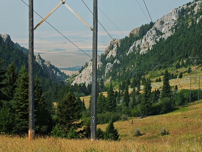
From
East. (also described upwards). A
good all weather gravel road with a hint of
hard surface leaves Mt86 at a sign. In the
open rangeland the views of the Bridger
Range are exceptional, except during forest
fire season. Progress is fast on this the
roller coaster road road, bouncing around
between a few scenic farms. Entering the
National Forest, progress becomes a little
less fast, and the views of the mountains
are relegated behind trees. There is an
unnamed intersection, that is less of a
problem when you go up this side. But coming
down it actually appears to have more
traffic diverting towards the north, than
this approach so far. But the option to the
north deteriorates into a very slow trail.
Alternate Approach from
East: (described downwards). Going
down the northerly way at the jct mentioned
above, the road becomes gradually less and
less used, then crosses a creek at about
6000ft. On the other side an even less used
ATV trail climbs again to 6400ft and shows
no signs of ending after 5.3 miles. At this
point it became too hot to follow it further
down for me on this ride. But it showed no
signs of ending Dayride with this point
as highest summit
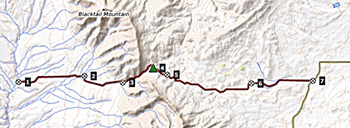
COMPLETELY UNPAVED ( < Ottawa Gulch Rd s(u) | Hyalite Canyon(ow) > ) Flathead Pass x2 , unnamed-1(sh) : National Forest land boundary on west side of Flathead Pass Rd > up Flathead Pass Rd > Flathead Pass > jct with unnamed road <> out and back beyond a low point (~6000ft), over another high point (~6403ft) on this road to turnaround point back up at 6200ft >> down east side of Flathead Pass Rd << turnaround point at jct with pavement on Mt86 > back over Flathead Pass > back to starting point on west side of Flathead Pass: 35.1miles with 4120ft of climbing in 5:14hrs (garmin etrex30 m3:20.8.23).. Notes: I'll consider this one a preparation ride for the real thing someday. It was so hot and hazy that you could barely make out an outline of a mountain, during yet another record fire season in California sending smoke and heat this way. 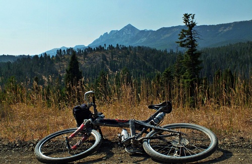 |
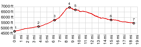
 From here to the
top the climb remains relatively shallow
except for very short climbs. An
exceptionally wide road reaches the summit,
where it suddently turns into a jeep trail
on the other side
From here to the
top the climb remains relatively shallow
except for very short climbs. An
exceptionally wide road reaches the summit,
where it suddently turns into a jeep trail
on the other side|
|
advertisement |
|
|
advertisement |