| |
| |
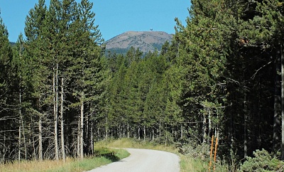
Sawtell Peak Rd(ow) I have seen this
microwave-reception dish on top of a
mountain several times from below. Looking
up from US20, it really does not look like
a very impressive climb. But then Mt
Ventoux does not cut a great view from
below either, and it is a cycling legend,
with enormous far reaching views. As far
as Sawtell Peak is concerned - it looks
more appealing from Shotgun Valley to the
south, than from the closest access point
on the GDMBR. After having cycled it, to
me personally - it is a kind of Northern
Rockies gravel version of Mt Ventoux -
sort of - kind of - in a stretched sort of
way. But 3000ft climbs on a bicycle are
rare in this area. Where this comparison
brakes down is - the people that travel up
here are almost entirely ATV drivers,
disguised as ninja turtles ... and the
occasional couple in a car, celebrating
their 53rd wedding anniversary.
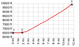
This is where the profile
starts, and also where the GDMBR comes down
potholly old Hiway 191. Sawtell Peak does
not look like much from this vantage point.
A regular long wedge, mostly tree covered,
except for that singular big cliff around
the top, on which sits a radio facility. The climb starts gentle, paved
and stays in the trees. Turning to dirt at
the jct with Stamp Meadow Rd ( an alternate
approach from the Island Park area), and
getting a little steeper, after a nice
little workout a radio tower appears. Can
this be the top already. Of course not, the
real climb hasn't even started yet. The next
view of the radio facility on top is still
framed by a road cut. It becomes clear that
the view and size of the telelescope at the
summit has hardly changed - the first hint
that this may take a little longer than
originally planned.
The bicycle can go just a few
feet higher than the road itself, to a
highpoint with a 270 degree view. It would
be 360 but the radio telescope is in the way
for 90 degrees. It really is as large as
suspected from below.
Dayride with this one way
point as highest summit (and no two
way summits)
PARTIALLY PAVED / UNPAVED ( < Green Canyon Pass | Monida Pass > ) Sawtell Peak Rd(ow) : Stamp Meadow Rd, 1.3 miles from jct with Yale - Kilgore Rd > Stamp Meadow Rd north <> out and back to the top of Sawtell Peak Rd(ow) >> <> separated out and back down Sawtell Peak Rd > US20 > Old Hiway191 north with turnaround point just before jct with Red Rock Rd : 45.3miles with 4400ft of climbingin 5:24hrs (garmin etrex30 m3:20.9.2, t20_22) Notes: perfect temperature, perfect weather, perfect light, perfect ride. On top I had a great conversation with the Barkers from Idaho Falls, celebrating their 53rd wedding anniversary today. I did see one other cyclist at the jct with Stamp Meadow Rd, Kurt from Park City, who agreed with me on the lamentable state of road cycling in rumble stripped Montana. |
 The interesting
part of this road starts past the Sawtell
Peak trailhead. This trail climbs the rocky
peak, that is visible from the top. The road
now too goes above treeline, flanked by
impressive groves of deadwood. Not until the
very last section does the viewshed also
include the west and north sides, that is
Sawtell Peak itself and Hebgen Lake. Behind
it, one of the gentlest of all CD crossings
over
The interesting
part of this road starts past the Sawtell
Peak trailhead. This trail climbs the rocky
peak, that is visible from the top. The road
now too goes above treeline, flanked by
impressive groves of deadwood. Not until the
very last section does the viewshed also
include the west and north sides, that is
Sawtell Peak itself and Hebgen Lake. Behind
it, one of the gentlest of all CD crossings
over |
|
advertisement |
|
|
advertisement |