| |
|
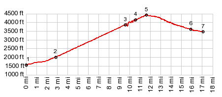
1.(00.0m,1600ft) START-END SOUTH: White Bird (village)
2.(02.9m,2060ft)jct with Chapman Creek Rd on right
3.(09.6m,3800ft)Old White Bird Hill Rd merges with new White Bird Rd at Poe Saddle
4.(10.6m,4110ft)Old White Bird Hill Rd diverges again from new Rd, just before summmit of new road.
5.(11.6m,4410ft)TOP
6.(15.9m,3630ft)route turns left, away from Old White Bird Rd towards new Hiway
7.(17.1m,1380ft)START-END NORTH:START-END NORTH: jct US95 - connection road to Old White Bird Rd
|