| |
|
|
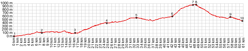
01.(0020m,00.0km) START-END SOUTH: Malaga, just south of harbor
02.(0125m.07.4km) Chaparral
03.(0100m,16.0km) alternate route along Rio de Campanillas turns off on right
04.(0400m,24.5km) road passes Almogia
05.(0550m,32.3km) Puerto de la Muher/Dehesa
06.(0610m,41.7km) Villanueava de la Concepcion
07.(0945m,47.3km) out and back turnoff to El Torcal is on left
08.(0950m,48.0km) TOP: point of highest elevation
09.(0570m,57.0km) A343 on left continues around el Torcal. Profile stays right
10.(0460m,60.0km) START-END NORTH: Antequera, north side
|