| |
|
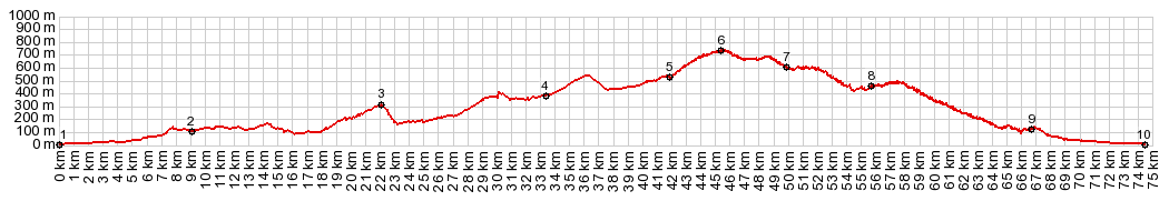
01.(00.0km,020m) START-END EAST: Malaga, south of harbor
02.(09.2km,120m)El Chaparral
03.(21.9km,0300m)profile turns right off MA3400 onto smaller road
04.(33.4km,0380m)route turns right towards Casabermeja
05.(42.0km,0530m)Casbermeja and start of climb on narrow curvy road
06.(45.8km,0730m)TOP: point of highest elevation
07.(50.0km,0600m)this point is marked as Puerto Marin on map - not a road jct
08.(55.0km,450m)point marked as Puerto Pereda on map - not a road
09.(66.8km,120m)route approaches A9 and a little later enters outskirts of Malaga
10.(74.6km,020m) START-END WEST: Malaga, just south of other endpoint
|