| |
| |
Vall d'Ebo s(u)
This little climb is a scenic jewel
on the Costa Blanca. I think there may be others
like this in the vicinity. But my route continues
north along the coast. Just thinking in terms of
pavement, this is really just a shoulder point for
Alto de Tollos or alternatively a shoulder summit
on Cv700. But if you include a short additional
canyon access track I can come up with the minimum
elevation difference to make this a separate page.
I spend the night there on my tour in a private
quiet spacious private room. The only problem is
the grocery store. There is one, but nobody knows
when or if it will open today - definitely not
before 7pm. So I buy some vegetables from the
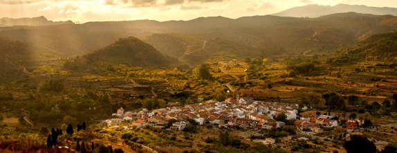
local bar. The next morning I leave this quiet town in its
gentle carst valley and do the short climb to the
summit. Surprisingly I see 50 to a 100 cyclists
coming the other way.
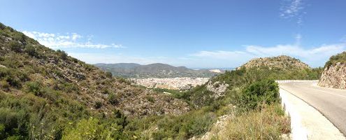
From South (described downwards). The reason for this popularity soon becomes apparent. It's the scenery and the wild curvy road. Some rain during the night washed all the haze out of the air, and the pictures I took I now miss sorely. The descend through the small limestone canyon is made more beautiful by the ultra blue sea behind it. There are several ways to complete the journey down to the coast. On my option, through the town of Pego, I see more cyclists than I have met on the entire tour sofar. They seem to be all male. Maybe their wives are at the beach, and maybe this arrangement of a beach-wife and a cycling-husband is what makes this location so popular - no idea - just a guess. For me it's the scenery.
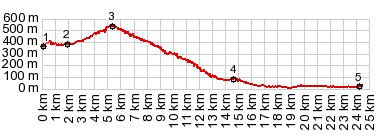
A Day on a Tour with this point as highest
summit: ( < Portell de Cati s(u), Alto de Tollos s(u) | Via Verde Ojos Negros s(u) > ) Vall de Ebo s(u): Vall de Ebo > Vall
de Ebo s(u) > Pego > Oliva > on various
bike trails and secondary roads following coast
> Gandia > Cullera.
|
|
|
advertisement |
|
|
advertisement |