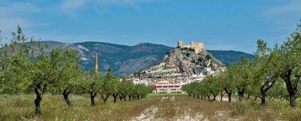
On aerial maps of Petrer an
enourmos block of a mountain appars behind it
and its castle: the Serra de Maigmo. This remote
little road curves over a shoulder of this block
of a mountain. The racing graffiti on this road
is evidence that the very steep northern side is
a popular bike race.
But before I can ride the road I have to find it.
Asking people in Petrer also was of little use.
They all wanted to send me over the larger CV80,
bypassing all the interesting stuff for a cyclist.
Even with a gps finding the route finding was
challenging. The point that I had missed, was that
I had to go back over on the north side of A31 to
find the start of this little road. On a map
without enough detail that statement is completely
illogical The road starts to traverse up a dry valley.
Below are the houses of Petrer with its maze of
backyards. The castle sits like a crown above all.
I take many pictures of the backstreet chaos,
contrasting with the old symbol of power and
authority above it. The contrast is what makes
this scene interesting. Unfortunately all my
pictures are on a stolen computer. There are
plenty of photos of the castle on websites. But
all I've seen have a very sanitized look, that
misses out on the garbage and lived in feeling,
which to me makes this scene really interesting. The road retreats in a forested valley, and
climbs over many miniscule waves in the landscape,
passing a remote farm. The goal, for most people
who travel this road is the Xorret de Cati - a
hotel of sorts, it really looks more like a
mountain spa, complete with trailheads, additional
roads climbing the slopes of Serra de Maigmo, huts
in the forest, and a nice sculpture of a climbing
cyclist. I also take several photos of it,
virtually identical to ones that I found on the
web. During my visit the hotel is closed - a ghost
hotel without any sign of life. The road surface
improves at the junction with another wider road,
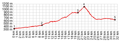
that climbs up from the Petrer side. Now the road makes a 90 degree turn to the north and climbs steeply to a well defined pass. The Serra de Maigmo and other surrounding ranges appear framed by forest. The top is in the trees and the road is covered with chalk
From South. (described
downwards). The many pounds of chalk on the road
on this side speak of many an exciting and
exhausting race finish at this point, and looking
at the profile you can see why. This is a very
steep slope up from Castella. The brake pads on my
fully loaded touring bike are working at their
temperature limit. The views down to the valley on
the west is of gentle rounded hills with
relatively modern appearing villages spreading out
over the valley bottoms, a more modern picture of
Spain than I have seen so far. At the end of this profile another great image
waits for me; the castle in Castalla. The main
road down from the summit seems to head directly
for it in a straight line, and I take several
pictures of it with cyclists in the foreground.
The linked pictures of a similar scene, I think
are taken a little to the south of the profiled
route, and have different foregrounds, and
probably better light conditions than I
experienced. The profile ends at a low point in
this bowl like valley. In order to get to lower
valleys you have to climb over additional summit
points. A Dayride with this point as highest summit: COMPLETELY PAVED: ( < Puerto
de Cabezo de la Plata | Cv801 Ibi - Alcoi ,
Vall de Ebo s(u)
> )
|
| |
| |