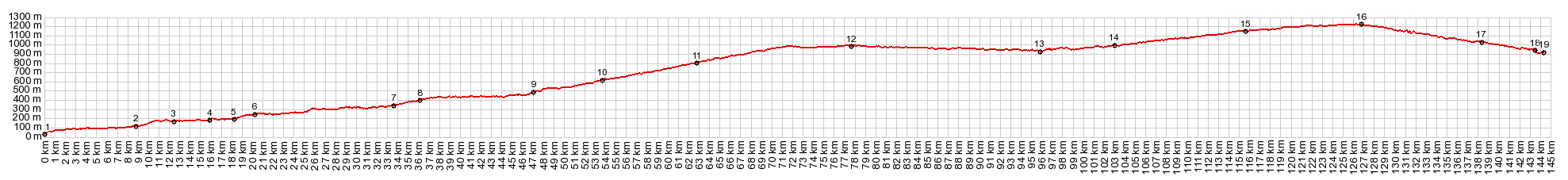
Via Verde Ojos Negros s(u) aka. Puerto del
Escandon The Via Verde Ojos Negros is
Spain's longest and best known railtrail. I
would divide the reasons for this popularity in
three categories: the bridges, the towns, the
tunnels. In addition to the 160km of converted
trail the profile below also contains an
additional 20km road approach from the
Mediterranean coast. On top of the Via Verde
just happens to also be a named pass, the Puerto
del Escandon.
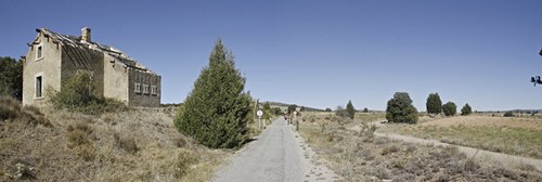
Soon after lunch I find the official beginning of
the Via Verde Ojos Negros. There is a clearly
marked signed and trailhead, immediately before
N234-A joins to the big old highway, about a km
west of Torres-Torres. I reconstructed the route
on the map included on this page. The mapped route
follows the road instead of the trail for the
first few km. Unfortunately the gps data for the
recorded route was on a stolen computer. But the
elevation and distance data are virtually
identical.
The beginning of the path is paved and a kind of
low, fast balcony platform, from which to admire
the villages, as they move by at a distance
perfect for photography with a normal focal
length. Approaching the twin cities Segorbe and
Altura, there is a section, where the surface of
the trail becomes extremely rough. The paved road
is just a few meters away. Since it also has a
less obstructed view, I choose the easy and scenic
option. Segorbe and Altura are the biggest cities on this
side of the summit along the Via Verde. This urban
area is big enough to exhibit many different
faces. I take pictures of narrow medieval streets
under an official Via Verde directional sign. The
official route goes right through the city. My
photographs are gone, and the ones on the web are
mostly of the walled castle on top of the hill,
filtering out the modern main street and the
chaotic street life. Soon afterwards I am back on the peaceful
bikepath along half height of a gentle valley.
Later in the day comes the first truly amazing
sight along the trail. The village Jerica appears
as backdrop to a picnic table and canon of some
sort, framed by a tree in spring bloom. The
village is dominated by a massive tower so that
the houses clustered below it appear to be part of
the same structure. While Mudejar towers like this
are a common occurrence in Teruel, it is the only
tower of this architecture in the Valencia
region, Its peculiarity is that it is not
attached to the church itself (constructed in
1634). While the origin and taste of this
architecture is Moorish, it was actually executed
after the Moors had been expelled from Spain It is getting late afternoon, so I look for a
place to spend the night. But nobody in the nearby
Casa Rurales answers the door or telephone, and
the two hotels in town have too many stars for my
taste. This is actually quite a tourist town, and
so I decide to ride further. In order to save a
little time, I take the road between here and
Barracas. There is virtually no traffic on it and
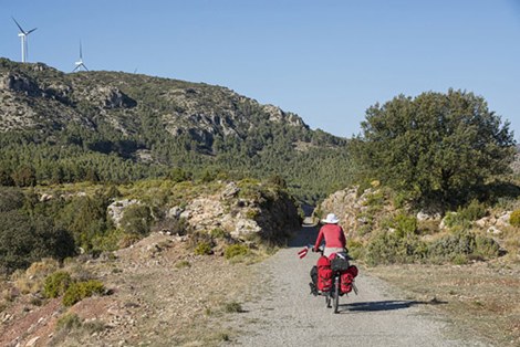
it also winds through the hills. At point 11 the Via Verde crosses the four lane
highway and also the little paved sideroad, that I
am on. The Via Verde is about to snake around a
large bread loaf of a mountain, topped by a forest
of windmills, while real trees are becoming more
and more sparse in the landscape. My little
sideroad on the other hand engages in a steeper
climb over the Cuesta
Ragudo shoulder summit. This appears to be a
gentle, but massive summit ahead. But actually, as
it turns out, this is the edge of a dry plateau
and up on top waits a vast and sweeping landscape. The next town is Barracas, and it is something
different all together to what came before. It is
not the summit, but it is a sort of divide to two
sections of the trail. From Sagunto to here the
Via Verde negotiated a total of 15 tunnels and 8
bridges over 70km. Between here and the end of the
old rails are 5 tunnels and 13 viaducts, including
the most impressive ones. This stretch measures 91
kms. However the last 36km past Teruel have sofar
not been converted to a railtrail. Barracas - proximity to the 4 lane road give it
the ambiance of a truck stop at first glance. But
there is a main street of old buildings with a
certain pleasant neglected medieval ambiance. Two
tiny store fronts house miniature grocery stores.
Two old men wait for children after school to sell
them overpriced candy - or visiting cyclists, who
might be interested in a can of beans for a euro.
While internet pages about the other towns along
the way, yield a baffling flood of historical
facts from Roman times over Moorish architecture
to Civil War battles, this town is mentioned
because of an exploding truck, carrying 25 tons of
ammonium nitrate fertilizer in 2004. The two hotels in town are hopelessly overfilled.
But on a backstreet, with the help of a jogger, I
find a Casa Rural, where I have the nicest home
for a day that anybody, anywhere could ever
imagine. But it was quite a piece of work to find
it. The next day my host leads me in her car, me
following on the bike, back to the Via Verde
trailhead, so that I can continue my journey on
the trail again. The majority of the trail is now
a packed pebble surface with some rougher
sections.
From now on the route has a more isolated feeling
to it. Now there are few enough cyclists on the
route, chances are good, that both will actually
stop and exchange information. I talk to an
Englishman and his Spanish guide who ride the
route in opposite direction. The landscape is a
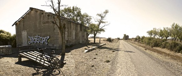
sweeping high plain. Periodically old station
buildings appear. The small rectangular brick
structures make great HD photographs because of
their textured walls. A lonesome bench in front
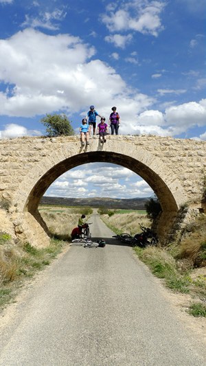
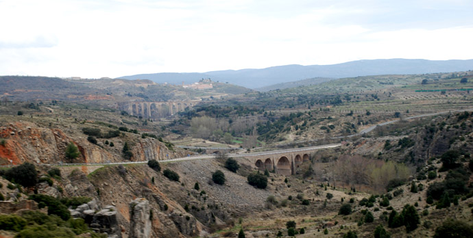
invites to stop and picnic. After a sweeping left turn the trail encounters
what in my mind (and probably most minds) is the
most interesting and visually arresting scene
along the entire route. The trail crosses the Rio
Albentosa on a large arched bridge, and
immediately afterwards plunges into a long tunnel.
There are actually three interesting bridge
structures in this vicinity and the best views
from the trail are of the other two: a road bridge
and a railroad bridge. The best views of the old
railroad bridge (that is the Via Verde itself) are
from the village above, Albentosa. There are many
perfectly lit images of of this scene on the web,
and the slide show links to several of them.
The next village Sarrion, comes just right for a
lunch stop, and so I take some time to ride
through its streets and find the singular grocery
store, hidden in an inconspicuous corner, very
difficult to find with my limited Spanish skills.
But I persevere, and orange juice with salami are
the result. Sarrion is maybe my favorite village
along the way. It is the opposite of touristically
exploited. The people I meet are happy to see that
somebody wanders the streets of their town - and
it is a picture perfect location (see photos). The next sections are quite long - no towns -
forest appears again - small bridges and nearby
brick ruins of old farms. The old railbed follows
in close proximity to the new rails. The operating
trains are small modern constructions, consisting
of only 2 cars, running twice a day in each
directions. Detours from the Via Verde to nearby
towns like Valverde are a little longer now.
Approaching the top, a long straight trail
tangentially runs towards the equally straight
highway. The top is a highway interchange and a
named pass, the Puerto del Escandon. A small,
modern railyard at the top shows no signs of life
whatsoever.
From North. (described
downwards). This description is going to be much
shorter, partly because the approach is much
shorter. Signs of life in the from of more
cyclists and more ambitious construction efforts
appear as the big city gets closer: Teruel.
Numerous bridges and tunnels follow one after the
other as a wide trail makes for a fast, but
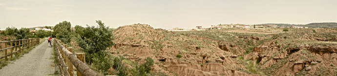
shallow descent. Valdecebro appears to sit on top
of a layer cake of badlands rock formations. The
rocks remind me of scenes in Utah. But the houses
on top are old medieval brick structures and not
some boring truck stop. The Via Verde continues a small distance past
Teruel. But the profile gets off the trail at a
convenient, but unofficial access point, which
minimizes the distance to the city. This is my second visit to Teruel. I wanted to come back to photograph all its bridges and Mudejar towers - and I did. But unfortunately the computer with all the images were stolen. This is a town, where a bike is of great convenience when looking for the best far vantage point on its hills and towers. Walking is really too slow.
History Railroads: The reason for the original
railroads is the mining district "Ojos Negros" in
the Sierra Menera, located about another 50km
north of Teruel. The remaining distance north has
not been converted to a railtrail. At the end of the 19th centery iron ore needed to be transported from Ojos Negros to the harbor in Sagunto. The history reads more like a history of American than European railroads. There already was a railroad, that served this corridor, the Ferrcaril Central de Aragon. But because of animosities between the two companies, a separate narrow gauge railroad was constructed, sometimes less than a hundred meters distant from the Aragon line, named the "Ferrocaril Minero de la Sierra Menera". The need for more transport capacity on the narrow gauge line caused that it stopped operation in 1972 History-Bicycling: The decision to turn
this into a railtrail was made in 2001. The last
additons to the trail were made in 2009. Sofar no
plans exist for the remaining kms to Santa Eulalia
in the Sierra Menera, which is only a couple
hundred meters higher than Teruel. A Day on a Tour with this point as highest
summit:
( < Vall de
Ebo s(u) | Puerto de
Santa Barbara > )
|
| |
| |