| |
| |
Tour Madeloc, Route des
Cretes
(including one way summit to Tour Madeloc) This is a narrow paved track of
steep and spectacular switchbacks, directly where
the Pyrenees meet the Mediterranean Sea. There is
no higher summit closer to this coast line. From
up here all that new condo architecture enveloping
the villages around small harbors become one
visually exciting bee hive of activity. Down there
is traffic without end, and up here you can only
hear the wind, and yourself breathe if you ride
hard enough.
I encountered many bicycles on this route, some
mountain, some racing. I was the only one with
full saddle bags. This route crosses its own
shoulder summit point, and then a short traverse
nearly on top of a short ridge leads down to Colle Molle. Four
roads cross here. For a short time the route to the tower is
slightly wider than before, and you meet a car now
and then. But it is still narrow enough, that I
always stopped to let it pass. Past some
decommissioned military buildings, the road is
held in place by a rock wall. This marks a short
exposed section. Immediately after that the road
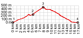
reaches the highest point on the two way
summit. Slideshow of the Route de Cretes two way summit
Slideshow
of out and back climb to the one way summit
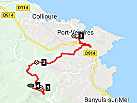
Dayride with this point as highest summit COMPLETELY PAVED: ( < Col de Pennes | Colle Mollo > ) Tour de Madeloc, Route de Cretes, addtional out and back: just south of Ine > sidetracks west > D81 south > Argeles-Plage > Collioure > Port Vendres > up Route Vinegraires > Col de Mollo(shp) <> out and back a little past summit of D86 towards Ermitage ND de Consolation > Tour Madeloc, Route des Cretes <> out and back to one way summit Tour Madeloc >> down Route des Cretes > Banyuls s Mer <> out and back on Route de Cebere (Rte9) south to next high point, Cap l'Abeille >> Rte de Cebere north > Port Vendre > Collioure > Argeles sur Mer > D114 and other north east <> out and back to sight see Ine > back to starting point south of Ine: 52.8miles 6218ft 8.6mph 6:10hrs (garmin etrex30 r5:19.5.4). Notes: another day of extremely strong north wind, that made even walking at the summit difficult |
 South.
(described downwards) The switchbacks stack up
on top of Banyuls sur Mer like a set of steps. A
few trees add to the landscape on this side. When
entering town, for a short time road conditions
improve, and the road width increases. Then the
surface becomes very rough for the last part.
South.
(described downwards) The switchbacks stack up
on top of Banyuls sur Mer like a set of steps. A
few trees add to the landscape on this side. When
entering town, for a short time road conditions
improve, and the road width increases. Then the
surface becomes very rough for the last part.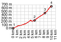
|
|
advertisement |
|
|
advertisement |