| |
| |
Kozica Pass In terms of popuation, this
part of Croatia is a linear country. The
line of population and tourism runs along
the coast, and this pass demonstrates
that, by leaving the coast. This signed
bike route is a complete escape from the
coastal traffic, in which it starts. On
the other side waits the impressive scenic
desolation of the Biokovo Natural area
As the road towards Hrasovac Pass rolls over the summit plateau, this turnoff is actually signed as a bike route, and that is a rare thing in Croatia. The road passes a cemetery terraced along the road, and then the karst limestone topograph of the Biokovo area begins in hearnest. Every once in a while a high bare peak appears in the summit area. But you have to wait to the top to get the full view. At the top a group of houses blend in with the grey natural limestone. From
East. (described downwards)
Switchbacks connected with long ramps lead
down into the linear valley, flanked by this
magnificent limestone mountain. The dwarf
vegetation next to the road frames the view,
but doesn't obscure it. The village at the
bottom is also named Kozica and contains a
number of war ruins. Slideshow of the section turnoff onto 6199 to Kozica on eastern approach to start-end west.
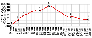
Dayride with this point
as highest sumit:
COMPLETELY PAVED: ( < Sveti Jure | ) Kozica Pass , Hrashovac Pass , D8 Igrane s(u) : Camp Sela, Zivigosce > Mala Duba > Milagraned D8 Igrane s(u) > Podgora > up 6198 > up sideroad through several villages > up D512 > up 6199 > Kozica Pass > D62 south > D512 south > Hrashovac Pass with short village detour > down 6198 > down unpaved road through villages > Drasnice > D8 east with short church detour : back to starting point near Zivigosce : 58.2miles with 4460ft of climbing in 5:57hrs (garmin etrex30 r5:21.11.24). Slideshow of section Podgora - turnoff onto 6199
|
|
|
advertisement |
|
|
advertisement |