| |
| |
Bouesou (Col de) The Pyreneen foothillis south of
Oloron-Saint-Marie contain many tiny roads over
low, but steep passes. This one is not the
lowest by a long shot. But it may be the least
known, only because the name does not appear on
any of the signs in the area. But it does appear
on the map.All the names of the surrounding
passes are found on the many direction signs in
the area.
Continuing up the steep valley ... After a short traverse through the quaint houses of Osse-en-Aspe, the narrow path quickly finds a tight valley and follows it to the top. The road emerges from the forest for a short moment between consecutive swithbacks to open a view onto the peaks behind the village Aidus. Looking ahead ... it seems improbable, that a road is contained within these constricted slopes. A steep climb on good pavement leads to a top without far views, From West. (described
downwards). It's a good thing that there is
basically no traffic on this road, because the
turns are tight, the trees dense, the road steep
and narrow. At about the half way point, the
decision must be made weather to descend all the
way back to the valley of the Gave d'Aspe, or
climb back into cooler temperatures towards the Col Pierre
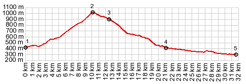
Saint-Martin. The profile does the first.
Dayride with this point as
highest summit: COMPLETELY PAVED ( | Puerto de Somport > ) Col de Bouesou : Bedous with detour > up D441 > Col de Bouesou > down D341 > jct with N134 <> out and back shopping and sightseeing tour to Oloron Saint-Marie with detours >> N134 south back to starting point in Bedous: 44.1miles with 3350ft of climbing in 4:39hrs (garmin etrex30 r5:22.09.08). 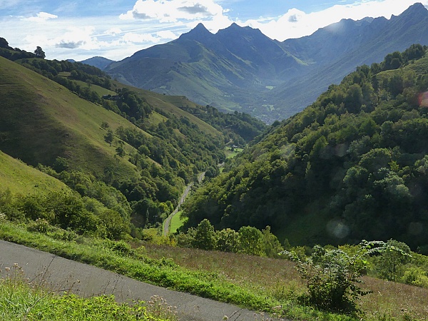 |
|
|
advertisement |
|
|
advertisement |