| |
| |
Schwarzbachtalwachtsattel Stringing words together
like this can be disconcerting to native
English speakers. The name means
black-creek-valley-oversight-saddle. But
even to German map makers seem to be
consternated by the length of this one. On
my map it is abbreviated to
Schwarzbachwacht. The only really
interesting part of this small saddle is a
section of alternate highway on the south
side, coming up from Ramsau.
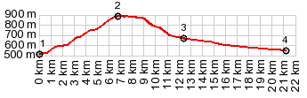
The profile starts at the
bridge over the river Saalach, and at this
point it seems all roads head to Reichenhall
(or in my case all others are closed). Here
is the turnoff to "Deutsche Alpenstrasse"
and a long fairly eventless climb in fast
and moderately heavy traffic leads to a
restaurant at the top.
From
South. (described downwards). But
this side is really much nicer - so nice it
makes the ride more than worthwhile. The
turnoff to a section of older highway is at
the very top. The profile follows this old
road "Alte Bad Reichenhallstr." which is
just as smooth and newly paved main road,
but contains many more turns and cows by the
wayside. A turnoff to Hintersee is
worthwhile. But actually that's a separate
ride all together. The landscape is more
open on this side. Watzmann and the other
peaks around Berchtesgaden liven up the
texture between the patches of sky. 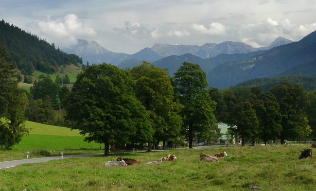 Dayride with this point
as highest summit:
COMPLETELY PAVED ( < Rossfeldstrasse s(u) | Hirschbichlpass > ) Schwarzbachtalwaldsattel , B20 Berchtesgaden - Bad Reichenhall , SR2101 Thumsee s(u) : Womostellplatz above Oberau > Bischofswiesen > Winkl > Bad Reichenhall with several km of sightseeing detours > Thumsee > B305 south > Schwarzbachtalwachtsattel <> out and back to highest point on road towards Hintersee >> B305 south > Ramsau > Berchtesgaden > back to starting point above Oberau: 50.5miles with 3940ft of climbing in 5:14hrs (garmin etrex30 r5:21.8.7) 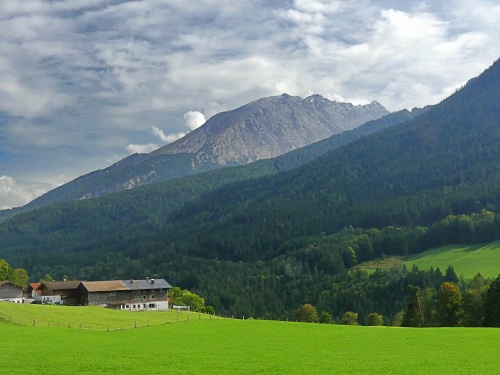 |
|
|
advertisement |
|
|
advertisement |