| |
| |
Hirschbichlpass Bikepaths over mountain
passes are a very rare animal. It is even
rarer to run into one by accident, which I
did in this case. The road crosses a
mountain-meadow divide between a national
park in Germany and a nature reserve in
Austria. Especially the German side is a
popular bike route, where cars are not
allowed on this perfectly smooth paved
road, with the width of a bike path. A German web site points
out that this route is of course less than
ideal for skinny tire bikes in the winter
[Note1 at end of page]. The person goes on
to say that the same is true for fall,
because of a thick cover of wet, slippery
leaves. This is not so "of course"
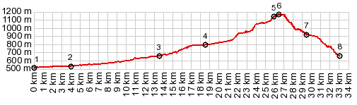
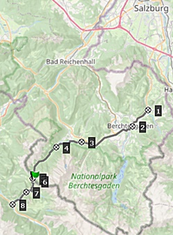
but it makes sense. None of the people I talked to, actually referred to this road as a pass. They called it just Hirschbichl. Most maps label it as Hirschbichlstrasse. But informational tablets at the top of the road, explain its role as a historic trading pass especially during the times of salt-trading, also notorious as a smuggling route. There was a border control here till 1963. My openstreetmap also labels it as Hirschbichlpass. external slide show with
pictures from this page +addititonal
Traffic from here on continues
to be heavy in my experience, but now it
consists exclusively of mountain e-bikes and
the occasional racing bike. In my case there
were two exceptions: a couple on touring
bikes and my own bike of the same kind. And
then "of course", there is the occasional
alm-experience-bus. It takes throngs of
tourists to the trailhead of their choice.
But cars are no longer part of the scene,
now that the road has crossed into national
park land, and is just barely wide enough
for the bus 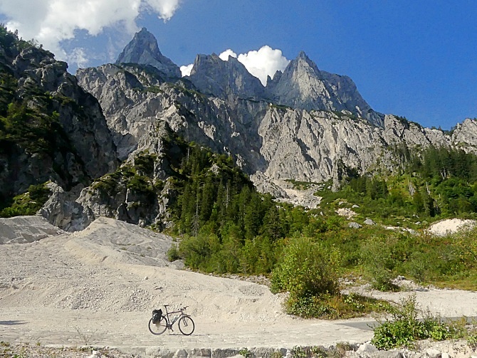
The road stays at the bottom
of the valley. But the views to the
skyscraper peaks become more common as the
road climbs. Especially interesting is a
trail - detour starting at Bichlalm. It
rejoins the road after a few kms. It is open
to bicycles and smooth enough for any and
all of them. The top of the road has a few
extremely steep pitches, followed by small
let-ups where one can catch ones breath (or
in my case get back on the bike). At the
German-Austrian border there is a sign with
name and elevation, followed by a cafe and
informational displays about the pass.
However the highest point of the road comes
a little later in Austria.
From West. (described downwards). The roadbed on this side is not as spotlessly perfect as on the German side, but it still is more than enough for any skinny tire bike. The steepness is advertised to reach 30 percent. It is extremely variable, and a few short pitches probably are that steep. The landscape on this side tends to be greener, and late light flattens the mountains into cutouts. This side is an Austrian Natural Park, but cars are allowed, even if they can't move any faster than a bicycle on the twisty upper section. Dayride with this point as highest summit: COMPLETELY PAVED ( < Schwarzbachtalwaldsattel | Vrsic Pass > ) Hochbichlstr s(u) x2: Womostellplatz above Oberau <> Berchtesgaden with several km of slow sightseeing detours <> Hintersee <> Hirschbichlstr s(u) << turnaround point ~750ft below summit: 45.3m with 4400ft of climbing in 5:01hrs (garmin etrex30 r5:21.9.9). Notes: I discovered this route by accident, so this was a real sight seeing tour. History In the 13th century international trade headlines were made not by computer chips or oil, but salt. Salt producers in Hallein and Schellenberg exported it over this pass south into Tyrol. In the long history of European confrontations, this pass played a minor role in wars that resulted indirectly from the French revolution. Rifle men were stationed on top, but the war happened else where. When troops were recalled on the two neighboring, much lower valley passes: Pass Strueb and Pass Lueg, the positions on Hirschbichl were also withdrawn. The Inn at the top is not only a picturesque place to relax. Hospitality at this spot has a long history, which starts with beer. A beer tap in the guard house dates back to 1738. Complaints by competing hosts in the valley of surrounding communities took till 1742 to be settled - in favor of the beer tap on the summit. In 1805, strengthened by further legal affirmations, the beer tap became a full fledged inn The pass was also part of a pilgrimage route. The destination was Sankt Martin bei Lofer in Austria with several chapels along the way, including the one near the top of this pass. ---------------------------------------------:
[Note1]:The word "of course" is frequently overused by Germans speaking in English (just watch a DW news program in English sometime, if you live in Denver it's channel 12.3), but I think it would fit here. |
|
|
advertisement |
|
|
advertisement |