|
|||||||||||||||||
|
|
|||||||||||||||||
| |
|
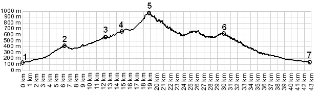
Col du Savel
For most people Col du Savel is just a shoulder point on the
way to Col de Turini, or any of the other passes along the
way. But combined with a short unpaved section, this pass
becomes the highest point on a route, that can be used to
connect two of my favorite medieval hilltowns on the coast:
Luceram and Coroaze. Choosing strictly increasing
approaches, like the profile below does, Luceram is a few km
off the route.
Immediately after crossing the river Le Paillon - a narrow road signed "Chemin des Mounts" turns back into a south easterly direction. A narrow smoothly paved path traverses up the hillside, passing many houses that try to make the narrow usable space between mountain and drop off into a living space. The road quickly reaches a top of a slanted ridge and turns back into a northerly direction. From here Luceram appears in the distance. The previously crossed bridge over Le Paillon is in the foreground The view on the other side of the ridge is over a much drier
drainage - a few badland outcrops and white washed houses,
speckled over the bare hillside. The route ahead soon appears
like white yarn rolled out over an undulating green carpet. The
path turns into a concrete ribbon the width of a walkway,
threading together a few spaced out houses. When Col du Savel
comes into sight, the road turns to dirt and steeply winds to
the top with a few short switchbacks 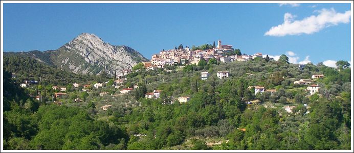
Coroaze from paved, lower western approach (telephoto view)
From West. (described downwards) I
still think this upper portion of Col du Savel, is the most
attractive part of the climb to Col
de Turini, at least on this particular approach option.
Across the hillside the road uses a few precarious walled in
switchbacks to negotiate its way down the mountain side. Below
that: more switchbacks - but the road appears much smaller,
proof that this part of the road is really much further away. Between here and Coroaze are also a few small climbs. This
town looks more impressive after you have passed it. The
cemetery has the best view in town. The lower part of this road
has many precarious blind turns that require great caution, at
least downhill and especially at the end of a long tiring day.
When these tight turns end, the traffic starts up and the road
approaches Drap
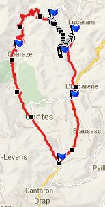
A Dayride with this point as intermediate summit is
on page Col de l'Orme s(u)
|
|
|
advertisement |
|
|
advertisement |