| |
|
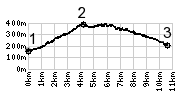
1.(170m,00.0km) START-END SOUTH: jct SR45-SP7, Fornaci Di Bagna, south east of Barga
2.(390m,04.2km) TOP: to the right are the narrow streets up to the church in Barga
3.(220m,10.6km) START-END NORTH: bridge over Sechio on SP7, south of Castelnuovo Di Garfagnana
|
|