| |
| |
SP3 Monte Baldo s(u)
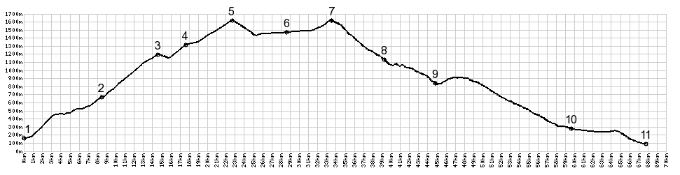
Monte Baldo has the geological distinction of having reached above the glaciers of the last ice age. Along the rolling top a diversity of plants has evolved that does not exist below in the areas once covered by glaciers. This road leads to the base of Monte Altissimo on Monte Baldo. There are many ways to construct loops over this summit, and probably dozens of just slightly lower shoulder points along the route. All of these can be cycled in an seemingly endless variety of loops.
There are many ways to cut this ride short and
roll down another variation of a Monto Baldo
climb. But San Valentino is the last chance to do
so. After that you are committed to the SP3
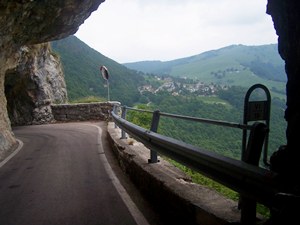
summit. Past San Velentino the road also takes on
a more rugged character. It dives into a short
tunnel, only to emerge momentarily and catch air,
makes a tight turn and runs through another short
arch of a tunnel. A few more smooth spline curves
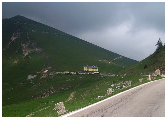
above treeline, and then the top comes into sight:
a large albergo in front of a cone shaped mountain
with straight lines. The background fades from
green into hazy gray. During my ride in this area,
the light was so flat - that there may have been
far views - but if there were - it looked like
just another variation of cloud and fog.
Apparently this flat light weather is pretty
typical here, at least in spring. From the summit
an unpaved track continues up the steep cone
shaped Monte Altissimo, and disappears somewhere
in the milky clouds above.
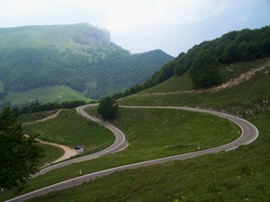
From South. (described
downwards) A long fast traverse leads to a
restaurant, that strategically occupies the only
obvious view down to Lago di Garda. But they don't
charge for looking. The road becomes narrower and
follows the top of a ridge in dense forest. The
route now follows a lower ridge across from Monte
Altissimo, which appears like the roof of a tower
above everything. Periodically deep valleys open
up in different directions. The flat light
actually gives these valleys a mysterious bottom
less look, with roads slicing up mountain sides
like lines on sheets of paper. At the next junction it is possible to return on
a separate descend towards the north. But I made
the mistake of misinterpreting the 30km sign to
Lago di Garda as "Riva di Garda", and the profile
also follows that option. The road winds around in
a long, but interesting way to reach the lake
close to its south end in Garda. Along the way SP8 climbs again and makes another
summit point, also above tree line. As the
mountains get lower towards this side of the lake,
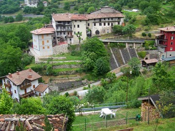
the villages have a more medieval "huddled
together" look. The current distance from the lake
can be gauged directly by how much traffic is on
the road. Less traffic means further away.
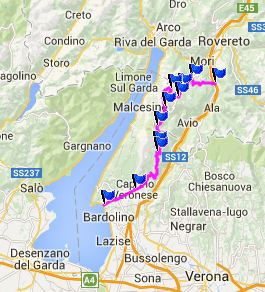
COMPLETELY PAVED: SP3 Monte Baldo s(u) , SP8 Monte Baldo: Passo
Giovanni : Torbole > Passo Giovanni with
detours > Mori > Pista Ciclabile south along
Adige > Chizzola > Brentonico > San
Giacomo > Boca di Navene > SP3 Monte
Baldo s(u) > Ferrara di M Baldo > Spatzi
> Pazzon > Garda > north along Lago di
Garda > Brenzone > Malcesine > back to
starting point in Torbole with grocery shopping
detour: 84.6miles with 7702ft of climbing in
7:20hrs (Garmin etrex30 m4:14.5.4) The last day with different start and end
points is on page: Passo Lagostrello
|

|
|
advertisement |
|
|
advertisement |