| |
| |
Passo Dei Redebus This pass connects two
valleys lined with vacation villages
coming up from the same direction, and so
it makes a nice short dayride, with still
a substantial climbing workout. There are
no truly great views from the summit, but
the great variety of church towers,
perfectly fitting into the landscape,
complemented by the villages and mountains
around them, leave many lasting images.
Finally before entering Paul
dei Fersina, the road turns west and climbs
the pass with a few switchbacks. The top is
heavily forested and is used as a depository
for all the timber that has been harvested
in the area. There is a limited view of a
far high dolomite ridge from a track, that
crosses one of these timber harvesting areas
heading north.
From
North. (described downwards) The
theme of the ride becomes even more
pronounced on this side. Churches at the
center of mountain villages appear glued to
the mountainous slope.
They make up the foreground to the southern
most, still distant, real dolomite ridges.
Later, arived at the valley bottom, the road
runs along two small lakes, the centers of
accompanying vacation villages. Traffic
increases drastically the closer you get to
the main road to Trento.
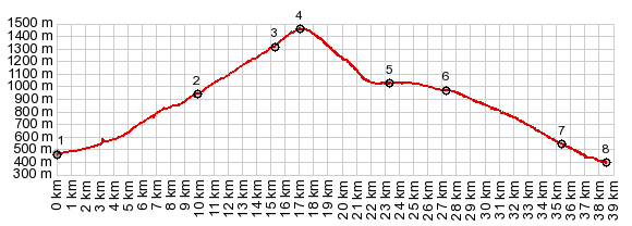
Dayride with this point
as highest summit:
COMPLETELY PAVED
( < Passo Di Veccena | Monte Grappa: jct SP148-SP140 > ) Passo dei Redebus , additional out and back: Levico Terme > with detours Pergine > Fassionago-Garait > Passo dei Redebus > Lago di Pazze > Baselga di Pine >Madrano > bike route to Pergrine <> out and back to Castello Pergrine with detours >> back to starting point in Levico Terme: 46.0miles with 4860ft of climbing in 5:14hrs (garmin etrex30 r5:21.9.29) 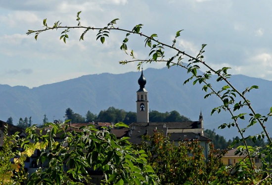 |
|
|
advertisement |
|
|
advertisement |