| |
| |
Monte Grappa - jct SP148 - SP140 My first reaction after
cycling this mountain was this: If you
were restricted to bicycling on one
mountain only - all your life, which one
would you pick ? This one might be a
pretty good choice. Actually it could be
the world's best choice. A total of 3
obvious, major roads meet near the summit
(actually there are at least 4, but the
4th one is not initially obvious, at least
to me). But counting other shoulder
summits and combinations with unpaved
roads and trails the total could be very
impressive. The summit is big enough to
get most everybody sufficiently tired and
worn out. The innumerable lower shoulder
summits along the way allow for feeling
accomplished with a little less elevation
gain. - The weather tends to be relatively
moderate and stable, unlike passes further
north amidst high mountain peaks, or in
the middle of continents where
temperatures tend to be more extreme. The only reason to maybe
reconsider is, that traffic in the
immediate front of the mountain, which
invariably have to be traversed, even if
only to connect climbing approaches) is
extremely heavy and squeezed dangerously
into very narrow roads - much like
(please excuse the hyperbolee) an
overweight opera singer is squeezed into a
corset. I am going to save the
"evolution of the later reaction" - after
I had time to think about this for a
while, for the end of the page. So back to bicycles and
bike-racing for a minute... The mountain
is understandably popular with bike
racers, an that even though the Giro
d'Italia has been up here "only" five
times. Most times the race did not finish
at the summit. War cemeteries and bicycle
race victory celebrations are not an ideal
combination. But more about the war
cemeteries later. In addition to
professional races there are several
cycling afficionado events, that are not
restricted by this. Just look at the variety of
all these approaches. The approximately
four major paved options meet within 200m
below the summit, and form 2 way summits
with each other. This is the highest of
those. But the next one is just a few
meters lower. Since this is the highest of
these two way summits, you could naturally
use any of the other approach options to
construct a loop that does not contain an
out and back section. So here is just a
quick overview of the major approach
options. 1. SP 148 - the main road
from the suburbs above Bassano (part of
this profile)
On the top you can sightsee
to your heart's content, not only far
mountain mesa vistas, but opulent fascist
architectural monuments, repurposed from
their service for peace, through
imaginative politics for the purpose of
fascism. ... It is a fascinating history
blend, that has to be untangled in the
hope of understanding it. Over 20 thousand
dead Austro-Hungarian soldiers have been
transported up here to be buried at the
summit. In addition to this sobering
historical puzzle, today this summit is a
multi-sporting summit. There are the
cyclists of course, both denominations.
The mountain bikers have their own
death-wish attractions. But all are
outnumbered by the hanggliders, who (at
least during my visit) outnumbered all
other visitors put together, as well as
sea gulls at a tuna cannery.They are
however forced to start their flights from
the lower slopes. Again : Mega -
cemeteries and launch pads are not the
ideal combination. I almost forgot - but
maybe it is obvious: You also have to add
the motorcycle contingent to the list of
visitors.
external slide show of pictures from this page +addtional external slide show of one-way summit pictures from this page +addtional Here is a short rationale,
when combining these two particular
approaches would be an appropriate choice.
Like all of the loops combing only
approaches from the south, this loop is
short enough, so that it still allows for
hours of sight seeing at the top during a
dayride. The loop over the next lower
summit point has to be a longer day ride,
combining the Feltre and Bassano areas as
low points (unless you partially double
back onto the original route and utilize
one of the traverse roads on the mountain
- an option that expands the possibilites
into something approaching infinity).
Approaches From the Valsugana main road
down in the valley, signs point to the start
of this climb. But approaching from the east
on Via Casale Nuovo, a sign directed at
cyclists details the Feltre - Grappa Loop,
and appears to send the cyclists up a dead
end at a restaurant. The true climb is a little
wider than this wrong turn I first took. It
starts with 6 switchbacks in the forest,
connected by long ramps. Soon the first far
view of the summit appears framed by trees.
From down here it looks like a big military
fort with defensive towers. This impression
will be corrected a few thousand calories
later.
Back on the original Cadorna
Road. Before reaching treeline, there is
really only one interesting view location
directly on this approach. It comes at the
junction with a traverse, that connects over
to the Feltre approach. This alternative
goes down to Cismon del Grappa. From just
before this junction, for the first time the
world of massive mesas to the north becomes
visible. After that it's back into the
trees. At a minute walking distance
from this junction (which is this
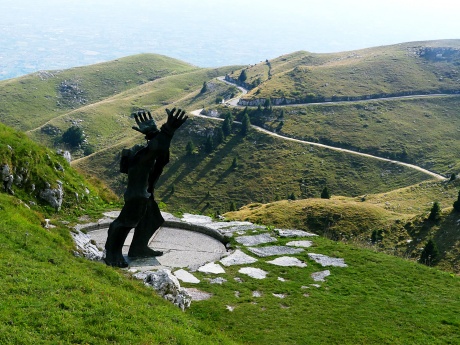
SP148-SP140) stands a fascinating sculpture
depicting the horrors of fascism (picture
above). If all the reminders of war and
death along the way didn't make an
impression, maybe this will start to do it.
It's origin, history and purpose are very
different from what waits at the summit. Slideshow of the SP148 and SP140 approaches
Once below treeline the next section hugs the cliff below overhangs, and between two short natural stone tunnels (there is a picture on the SP140-SP141 page). This is not the kind of tunnel where a thunderous batallion of cars pursues you, but the kind that are just plain fun to cycle through. Outside the mountain is made up of rock folds, that look like a bunched-up curtain. The green folds descend straight into the valley. A large number of hanggliders suddenly appear at eye's level. At the transition to the third section of this decent, they seem so close, you can virtually see them make decisions on where to turn, in order to catch the next updraft. The third section is largely
in the trees. 20 switchbacks, partially
lined by cypress galleries, lead down the
regular slope like a stair case. Through the
cypresses you can make out a few low knolls,
the last remnants of foothills on an
otherwise perfectly flat plain, stretching
to the Adriatic sea beyond the horizon. Some
are crowned by towers or mansions, The road
enters Semonzo and goes over a virtual white
carpet of racing graffiti, adjacent to a
small cathedral. But the racing graffiti
takes a quick end. The profile now runs for
a short distance on SP26 - a truly horrible
awakening to the reality of traffic in this
area, after this dream like decent - but
then quickly leaves this nightmare road in
order to find a few more meters of decent to
maximize the downhill. Sidetrip to Cime del Grappa(ow)
My reaction was: In order to
compete with this dramatic view, whatever
else is up here has to be pretty dramatic
too. The answer: The remains of 25 thousand
dead soldiers have been transported up here
memorialized. The result is a walkable set
of terraces. Through it leads a summit
boulevard of sorts. Everything is larger and
monolythic than life. Best to experience it
first hand and try to find your own words. Dayride with this point as
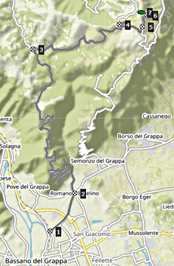
highest Summit COMPLETELY PAVED: ( < Passo
dei Redebus | Monte
Grappa: jct SP140-SP141 > ) Monte Grappa jct
SP148-SP140 , additional out and
back: Romano D'Ezzelino with
detours > SP149 north <> partial
out and back to high point on road to
Campeggia > SP148 west > Cima del
Grappa: jct SP148-SP140 <> out and
back to Cima del Grappa(ow) >> down SP
140 > Sermonzo del Grappa > Mussolente
> Fellette > Bassano del Grappa >
back to starting point in Romano D'Ezzelino:
45.1miles with 6560ft of climbing in 5:28hrs
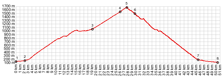
(garmin etrex30 r5:21.10.1)
Notes: the first truely
perfect day, the right temperatures with
clear sunlight and no haze. But traffic in
front of the mountains is heavy on very
narrow roads.
Slideshow
of the least section to the Out-and-Back
summit:
History WW1: The Monte Grappa
war stories date mostly from WW1. Let's face
it, Monte Grappa did not have a happy
childhood. Consequently it did not develop
into an ordinary, peaceful and happy mountain.
The area below it was first settled by the
Romans, invaded by barbarians after the fall
of Rome, then ruled by the tyrant Ezzelino. it
was subsquently annexed by the Venetians, only
to be sold to the Hapsburg empire (Austria) by
Napoleon, and then annexed by a young Italian
kingdom in 1866. By the 20th century Tyrol and
the Austrian cultural influence was dominant
from here north. WW1 was a very bloody period
here, revolving around hostilities between the
Austro-Hungarian empire and Italy. Before any
of the hostilities began, a major military
supply road had to be constructed in 1916. It
was named after general Cadorna, a heroic
general who saved Italy, or a butcher who made
his troops run uphill into open fire,
depending on how close you were associated
with the latter. That is the wester approach,
described above. Three important battles were
fought between the Austro- Hungarian empire
and Italy on these slopes. Italians occupied
the top, but there were Austrians on the
northern slopes. After the first battle, the
Italians built up the summit. Today we can be
amazed at the result, and what some people are
capable of in war. All this fortification
building paid off. The next summer's offensive
(1917), in which the Austrians wered aided by
the German Alpenkorps failed to take the
mountain. The Italian defensive line along the
Piave River, which is an unmistakable landmark
when climbing the mountain on a bike further
north - held. This last battle for the
mountain was the biggest. While the major
battle during the summer only lasted less than
2 weeks, the time and effort invested to
further turn the mountain into a defensible
fortress took till the next spring, ten months
to be more specific. Amongst the newly updated
Grappa military structures was an undeground
gallery, consisting of 5km of tunnels near the
summit with the name "Galleria Vittorio
Emanuelle 3". Along with that, military
barracks were built at the summit, to allow
direct access to the tunnel system. Today it's
a musem. The Austros tried again to take
the summit, the following year, again during
the summer. Again the mountain top remained
Italian. The next year it was the
Italians who attacked the Austrian positions.
They did not win an outright victory. But it
forced the Austrians to strengthen their
positions on the mountain, thus depleting
resources on the strategically more important
front lines along the Piave River. This marked
the beginning of the end of the Austro
Hungarian empire by late in 1918. Soon after
that Czechoslovakia declared its independence,
which marked the beginning of the end of the
empire. It was during the bitter times
after WW1, which only lead up to WW2, that the
surreal depository of soldier bones at the
summit was erected between 1925 and 1932. Even though roughly 10 thousand
of the 23 thousand sodlier's remains are
unknown, the authorities took it upon
themselves to assign a military decoration to
each soldier on the Italian side, and
prominently display it, as part of the
monument. Of the 23 thousand assumed remains,
10295 are said to be Austro-Hungarian. They
are buried a little to the side of the
monumental 5 gigantic concentric circles. This
monument is said to "be inspired by the art of
military fortifications". You can walk down a
bombastic 250 meter "curtain of stone"
(walkway), flanked by monumental stone blocks,
listing the location of the major battles.
Heading for a grand view of the plains below,
you are met there by a small chapel. It houses
a madonna, which is said to have been horribly
disfigured by the enemy in 1918, und thus
deservers this special veneration, amongst the
thousands of dead soldiers. If it is not
obvious, it might be worth mentioning that
these have been disfigured even worse. Still -
the madonna inside this small chapel has been
the subject of blessings from pope to
caridinal, and is still subject to pilgrimage
every August. Making this place holy helps
justify what happened here, and it helps avoid
uncomfortable questions. If it is religion,
questions are not called for. Faith and
acceptance are called for. The madonna also
seems to place a an exclamation mark on this
statement: This is our lost land, and if other
sacrifices are demanded to reclaim other lost
lands - we the facists - will make them. This
is not the only bone depository along old
Austrian front lines in Italy. But I suspect
Monte Grappa is by far the most impressive.
You cannot beat this location. It was also during these bitter
times after WW1, that the allies decided to
give South Tirol, an area that is German
speaking and culturally Austrian to Italy.
Monte Grappa is not part of South Tyrol, but
it is not far away to the north. South Tyrol was now part of Italy, and speaking German became illegal for a while. But South Tyrol proved impossible to be culturally appropriated by Italy. Facist architecture was supposed to help a little. It was employed to help say "this is Italian and it will stay so. The sons of the Romans have returned". This monument marked the "new" Italian territory and the monuments were sentinels on its borders. They were employed to also help justify the lives lost during the acquisition.
WW2: Oh how
alliances can change in just a few years. The
Austrians were now part of a German led
effort, headed by an Austrian, working hard to
convince the Italians do be on the same side
in the next war. Everybody unite for fascism
! During this time the summit area was
used by the Italian anti-fascist Partisans to
disrupt fascist transportation lines down in
the valley. During this episode of history,
the fascists killed Italian Partisans in a
nearby cave. At the point
where SP140 and SP141 come together
stands the only monument, that I could find on
this mountain, that commemorates this period,
pre WW2 fascism. The name of the tortured
sculpture is Al Partigano, and it could not be
more different in sentiment to the
bone-depository. You might expect that this is
a more recent addition, and you would be
right.In 1974 Augusto Murer added this
monument (1st picture on this page). The
sculpture happens to also stand near the
entrancce of the Galleria Vittorio Emmamuelle
3. It seems this mountain is so crowded with
remnants of war, sooner or later each one has
to vie for its own real estate. Cycling: After these
long historical hostilities and their
consequences, a bike race becomes a very
friendly hostility indeed. In 1968 the Giro
d'Italia ventured for the first time up the
slopes of Monte Grappa. They chose the
relatively wide old military road (western
approach shown above). A relative newcomer by
the name of Emilio Casaline won over favorites
like Eddy Merckx and Felice Gimondi. There
have been 5 subsequent visits by the Giro (as
of 2017). During those times they chose
smaller roads with steeper approaches from
Semonzo (eastern approach above) and from
Caupo.
So now ... continuing from the
introduction: Recap: My introduction was also
my first reaction. But now my reaction, I'd
like to think is this: This is an area where tragedy,
history and interests collide to form
something, that is much bigger than its
individual parts. Yes - there are endless and
beautiful road climbs. Yes - hanggliders love
this place. But - thousands of people have
died here. Monuments to war and politics are
all over the place. Some of them have been
built for cinical, political reasons. Much of
this remains unexplained in the abundant
forest of signage along the way. And still -
this is a kind of pilgrimage site, where all
kinds of people meet, along with all kinds of
interests and intelligence levels. Sometimes
they not only meet, they collide. This place
makes you ask questions about history, people
and their motives, diametrically opposing
world views, and the tragedies that ensue from
all this. ... and a great place for a bike
ride ... because what could be more important
than that ? So back to the beginning. There is one more sneaky reason, why this just might be the best cycle climbing mountain ever. As hinted above, there are actually many more climbing and riding possibilities on the north side, from the valley and canyon of the Piave. Grappa is actually a "massif" not just a "Cima". And as a final "by the way". The name apparently does not come from the variety of wine, comprised of stems and wine-making leftovers (also named Grappa), but has something to do with the limestone cliffs in this area. - Happy biking. |
 Further up, a
sign directs riders to a viewpoint. I love
view points. I am a tourist. I took the
turn-off. I followed it for several km to a
high point, where a cable way was used to
supply troops during WW1. This road descends
slightly then, and I turned around. ...
Still - more loop possibilites
Further up, a
sign directs riders to a viewpoint. I love
view points. I am a tourist. I took the
turn-off. I followed it for several km to a
high point, where a cable way was used to
supply troops during WW1. This road descends
slightly then, and I turned around. ...
Still - more loop possibilites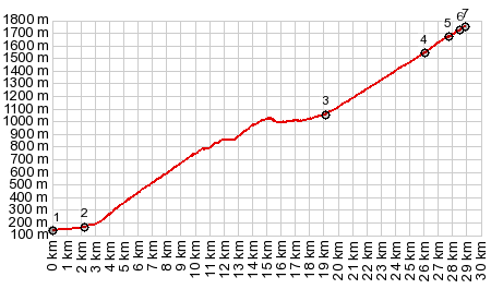
 The out and back to the
summit is so close to this two-way summit
point, that not visiting there on this loop
is not really a sensible option - at least
once. A few more switchbacks and the road
dead ends at a big restaurant, where
tourists are supposed to drink their beer
and lemonade and spend their money. Past the
large parking lot you can go a little
further on a paved path, that is a perfectly
bikable narrow path, that dead ends at a
locked gate, labeled as a military building
of some sort - a pefectly peaceful spot to
have lunch in solidarity with an incredible
panoramic view. Riding a bicycle above this
road on the trails near the cemetery is not
allowed.
The out and back to the
summit is so close to this two-way summit
point, that not visiting there on this loop
is not really a sensible option - at least
once. A few more switchbacks and the road
dead ends at a big restaurant, where
tourists are supposed to drink their beer
and lemonade and spend their money. Past the
large parking lot you can go a little
further on a paved path, that is a perfectly
bikable narrow path, that dead ends at a
locked gate, labeled as a military building
of some sort - a pefectly peaceful spot to
have lunch in solidarity with an incredible
panoramic view. Riding a bicycle above this
road on the trails near the cemetery is not
allowed.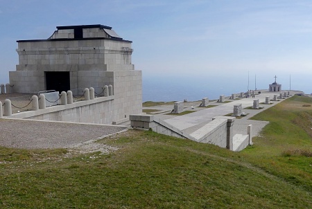
|
|
advertisement |
|
|
advertisement |