| |
| |
This is a small, but steep
climb onto an oval shaped hill, in a very
strategic position in front of the
dolomites. Below to the north are the
enormous braids of the Tagliamento River, as
they exit the triangular peaks around
Tolmezzo. On the lower south side is lots of
racing graffiti, spurring on cyclists whose
name will live until the rain washes them
away. Signs along the road call this "the
Wall of Ragogna", and the "Beginning of the
Alps", and once in a while the words "Giro"
and "Tour" appear also. All the evidence
mounts up to say that this is a very popular
racing summit. The road is not wide, but not
really narrow by local standards, and paved
as smooth as an ironing board.
The name of the actual mountain is Monte Muris. Both Muris and Ragogna are also towns at the foot of the mountain. Ragogna also serves as name for the route.
This climb is short but steep.
On the Saturday I was there there, I was in
the company of several dozen other cyclists.
This side has only one prominent view of
Tolmezzo and the river below. For me it
comes as a welcome rest between steep
switchbacks. Immediately before the top is
a junction. To the right it leads to appears
to a restaurant, but no great views that I
could find. It branches after 50m, but no
matter how hard you try you end up at
private property areas. But at the junction
itself stands a partially reconstructed WW1
bunker. A sign explains this defensive
positions in Italian. Much of the structure
was built by the Austro- Hungarian side
after the WW1 battle that happened up here.
(More in the history part below). As it turns out, this junction
with all the signs, pointing to nearby
villages, is not quite the summit. Turning
left here the gently climbing road leads
along the ridge. There comes an innocent
looking trail junction, where a small trail
leads along the edge of the cliff to a
picnic table. This is the place with all the
million lire views, the Tagliamento with its
untamable gravel braids below, the villages
with the church towers fronting the mountain
cliffs, wedges of framed dolomitic triangles
in the distance. This also happens to be the
summit. 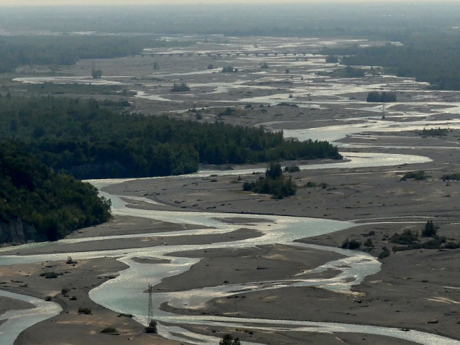
From
West. (described downwards). The road
switches to the west side of the mountain.
One more picnic table at a the next
trailhead, quite a bit lower, is the choice
position to study the braids of the
Tagliamento as it seems to head as straight
as braided rivers can for the horizon. Just
beyond that point it ends in the Adriatic
Sea. One more ramp through the
trees, as the road passes several WW1
bunkers; then you can take a left and
connect back to Ragogna, or go right and
actually cross the Tagliamento. This option
follows a road hugging the last vestiges of
the foothills, and then head straight for
Splimbergo. The profile should stop at the
bridge where the road crosses the
Tagliamento. However due to the amazing fact
that the river looses another 200ft very
quickly, during the short ride to the next
bridge downriver, I also included that part
in the profile. According to the map, this
is actually the shortest through-going paved
route in proximity of the river. This shows
how much respect the Tagliamento floods have
earned over the years. The Romans actually relocated
the lower part (running on the plain) once,
trying to control the river. But after two
disaterous floods it was decided to just
give it the width it demanded. This idea
seems to be coming around again, even for
less tempestuous water ways. The flow of
this river varies between 80 to 1600 (forgot
the units. but it is volume/time and a
factor of 20).
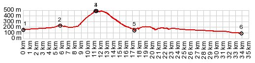
Dayride with this point
as highest summit
PARTIALLY PAVED / UNPAVED ( < Monte Grappa: jct SP141-SP140 | 58064 Moscenice - Brsec s(u) > ) Monte Di Ragogna: Passariano > Codroipo > unmarked narrow paved road following Tagliamento north on east side > Turrida > San Odorico Al Tagliamento > combination of roads and unpaved Cyclavia Tagliamento paths north > Dignano > Carpacco > Villanova Di San Daniele > SP74 north with detours > Ragogna > Muris > Monte Ragogna s(u) > Pinzano Al Tagliamento > Splimbergo > Dignano > same unmarked road along Tagliamento south > Codroipo with shopping detour > Passario: 65.1miles with 2420ft of climbing in 5:53hrs (garmin etrex30 r5:21.10.22) History WW1: Like Monte Grappa, this mountain top was the sight of fierce WW1 fighting. The main stratigic objective here was not so much in the mountain top itself, but controlling the line along the Tagliamento river. The top of Monte Muris/ Ragogna was an instrumental aid in this. In Novermber 1917, forces of the Austro Hungarian/ empire along with German forces succeeded infiltrating the northern slopes and attacking the Ragogna mountain top, held by Royal Italian forces. In the course of deteriorating Italian positions, the rest of the Italian forces retreated over the Pizano bridge ( bottom of western approach ) and left the defenders of the mountain top on their own. They went as far as actually destroying the bridge to keep the enemy from advancing. To understate conditions: without the bridge escape for the Italians remaining on the mountains, was also more difficult - but not impossible. About 600 Italian infantry managed to make it to the other side of the Tagliamento via the next bridge downriver ( probably the one in the first picture ), before it too was no longer passable. After the battke. the remains of about 400 dead Italians were collected in the forest by inhabitants, along with hundreds of Austro-Hungarian remains. While Italian forces gave up Monte Ragogna, it allowed them to strengthen their defense along the Piave River and also Monte Grappa. In the end this proved more important to winning the war. Cycling: So - compared to other famous racing climbs this one is relatively small, but steep. However - there is nothing that keeps race organizers to make cyclists go over the summit multiple times. In 2020, the summit was part of the stage Udine - San Daniele, and included a finish with two loops over the summit with a third ascent, finishing on top. 1800 spectators were allowed along the line, each one identified with a color bracelet, which was a first in spectator regulation history. The climb ascended the tight switchbacks on the southern side and decended the less curvy road on the Splimbergo side. The climb was also on the 2018 Giro. But that time it was an intermediate climb, finishing on the higher Monte Zocolan, many km to the north.. |
|
|
advertisement |
|
|
advertisement |