| |
| |
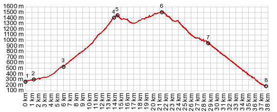
Monte Grappa: SP141 near jct with
SP140(sh) This shoulder point consists
of alternate Monte Grappa approaches,
merging ~800ft below the summit. Parts of
this route on the eastern approach are
very narrow and are posted with "closed"
signs, that have been a kind of
permanent fixture in the last years. But you can
get through on a bicycle. Other parts on SP140 are
extremely steep.
But back to the bottom.
Actually the turnoff on the west side of
Crespano del Grappa is really not obscure at
all. Coming from the north I was just too
anxious to start going up some not so
clearly signed paved roads, that all dead
ended. The right road has a sign directed at
cyclists ( but only the turnoff, and then quite a
ways up) with the name Grappa amongst others. This
sign includes extraordinarily,
intimidating average grade information about
the road ahead. All this information did not
keep me from taking yet another wrong turn
and do more extra out-and-back climbing at
the next round-about.
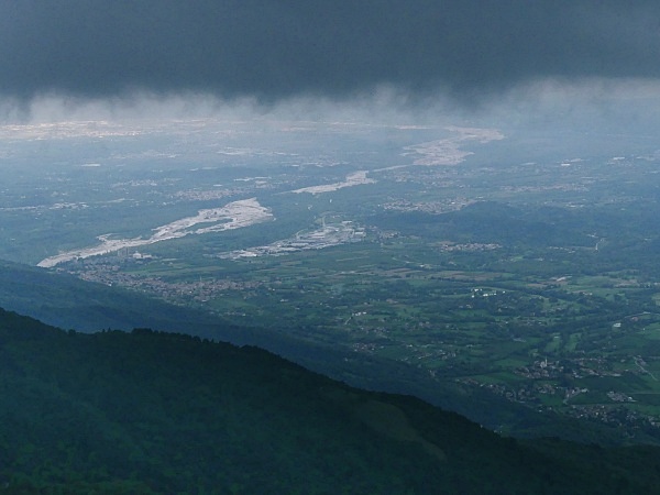
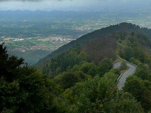
The last switchbacks emerge
above treeline. In my case one last ray of
sunshine illuminated the gravel braids of
the Piave Delta. Dark clouds were below my own
elevation, and the limestone patterns of the
Grappa slopes were truncated by grey. At the
next junction you can also make a loop by
going back down towards the right. This point actually
comes juts before the designated "Cime Mandria".
Do taking a right here does not actually reach the
Cime Mandria, and going straight you don't drop 100
meters before climbing to a higher point. So far I had seen one car on
this climb - admittedly a light traffic day,
a day when it was supposed to rain, and had
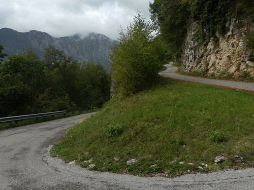
not yet started. Above here the road is so
narrow, that it appears like a bike path,
and those were the only vehicles I saw. A
small descend leads to a small climb to
another gap, all above treeline. scenery
obscured by clouds, and mellow climbing to a
summit point just before the road meets up
with SP140. This part includes the closed
section, which includes several tunnels
(maybe 4 or 5 - at this point I was too wet to count
accurately to 4) along a shelf road section in
the woods.
From West: (described
downwards) There are more notes on this
approach on the SP140-SP148 Cima del Grappa
s(u) page. Just this much here: It always
amazes me ("always" referring to the 2 times
I have experienced this) After a long
screaming decent Borso del Grapp comes into
view, and after all this fierce decenting,
Borso is still far below like a
carpet made of little square patterns. The
sign announces the 20th of 20 upcoming
switchbacks, in a long count down before the
landing. The road is wider now, and cars
exist, quantity depending upon weather, day
of the week and season. But in my experience
it is still much lighter than anything west
of the Brenta Gorge (and also much closer to
Bassano del Grappa). Dayride with this point as
highest summit
COMPLETELY PAVED ( < Monte Grappa jct SP148-SP140 | Monte Di Ragogna > ) Monte Grappa jct SP141-SP140(sh) : Romano D'Ezzelino > Crespano del Grappa with several miles and ~1700ft climbing detours due to wrong turns > Fieta > up Via San Andrea > SP141 south > Monte Grappa SP141-SP140(sh) > down SP140 > Semonzo del Grappa > back to starting point in Romano D'Ezzelino : 34.4miles with 5930ft of climbing in 4:39hrs (garmin etrex30 r5:21.10.4) Notes: a late start on a day when it was supposed to rain all day. But instead the weather held for a while, and then deteriorated much later than prognosticated, which seems to be a habit here this year. Light to medium rain started near the Cima Mandria area. -I fell on one of the switchbacks down to Semonzo, due to a slipping front tire. This is at least the second time that a helmet probably helped me escape a serious injury. |
 This climb consists of very steep switchbacks in the
forest. First - the long ones, separated by
7 or 8 ramps, then the short ones,
about 17 of them, divided into 2 groups by a
straight section. I walked a good portion of
these - very steep, or maybe they seemed
steeper after the initial work.
This climb consists of very steep switchbacks in the
forest. First - the long ones, separated by
7 or 8 ramps, then the short ones,
about 17 of them, divided into 2 groups by a
straight section. I walked a good portion of
these - very steep, or maybe they seemed
steeper after the initial work.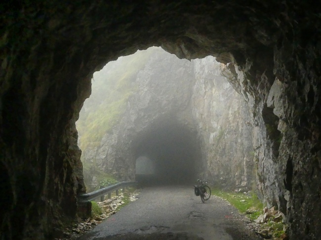
|
|
advertisement |
|
|
advertisement |