Passo del Lucese
I happened to find this little
pass on the map, while looking for a day loop
possibility over the better known Passo del Vestito.
But then on the road, I couldn't find, until a
sign appeared in front of my face saying "Passo
del Lucese - this way" in Italian of course. I
think this would be one road I would ride a lot if
I happened to live here.
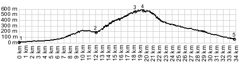 |
1.(10m,00.0km)
START-END WEST: Capezzano Pianore:
jctSR439 - Via Italica
2.(174m,12.0km) profile turns left onto
small road from SP1
3.(547m,18.3km) turnoff to right goes to
various small villages and the valley
4.(580m,20.0km) TOP: point slightly before
Passo Del Lucese; pass elevation is 558m
5.(80m,33.8km) START-END WEST: SP32
terminates onto SP2, south of Borgo a
Mozzano |
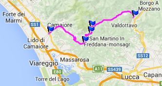 Approaches Approaches
From West. The approach
starts several kms west of Camaiore, where a sign
directs Lucca bound traffic to the right. This is
counter intuitive, but going to the left leads to
many dead ends in the mountains (according to my
limited experience)
The road to the right climbs up the lower hills of
the Apuane ridge, apparently heading for a low gap
containing a group of houses. Traffic here is
still almost as heavy as on the unpleasant SS1 in
the valley. But climbing further, a sign in the
forest comes to the rescue: "Passo del
Lucese" it reads, and directs those that are
interested up a very narrow tunnel through thick
brush forest up the hill. The turns and
switchbacks seem to take no end, even if they are
all are very short, tight and narrow.
It seems, that in this area every climb is under
the scenic ban of some hilltown, and this little
pass is no exception. The view here is more gentle
and isolated than on the rugged Passo del Vestito.
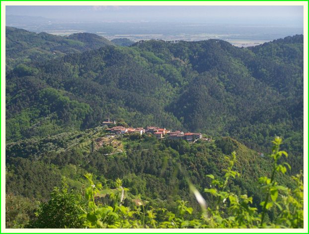
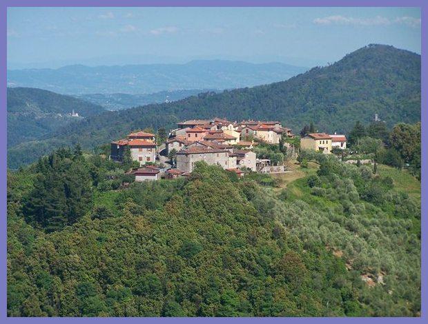
Somewhere on a mildly rounded hill, between the
road and the important ancient town of Lucca,
covering the top of a rounded hill perfectly like
a tablecloth, Migliano is decked out. First it is
at eyelevel, then the pass climbs above it, and
the valley becomes visible in the background. The
eyes look for big brother Lucca in the distance,
but can't find it - probably too hazy. The road
traverses further along the edge of the rounded
hill. Before the summit is reached another
appealing tiny road leaves to the right direction
Lucca. Curving through the forest, and keeping the
pass top in sight on the GPS on the handlebar, the
road seems to make very little progress to get to
it. Then finally a group of modern houses in the
woods line the road. The sign Passol de Lucese" is
bigger than a pass sign. It seems Passo de Lucese
is also the name of a town.
From East. When I look
at my Belletti 1:300000 road map, there seems to
be some confusion which way this pass descends. It
looks like there are options to stay on the west
side of the ridge, as wells as a descend towards
the valley of the Serchio. However, in reality
most of the descent happens before that junction.
It happens in the form of closely spaced
switchbacks in dense forest.
Then in Convale, a junction with a crossing road
would merit more exploration, that I think would
be very pleasant riding and according to the map
would yield much more climbing than this pass
(towards north along the Apuane ridge). This
profile descends straight as an arrow towards the
valley of the river Serchio, and meets it near
Borgo a Mozzano.
A dayride with this point as
intermediate summit is on page: Passo del Vestito
|