| |
| |
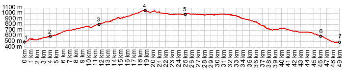
Cuesta de Ragudo(sh)
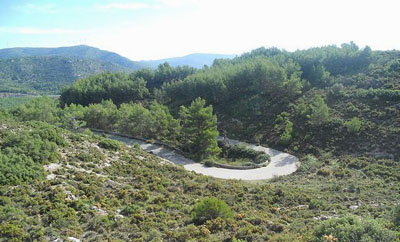
This small, paved road, virtually
without traffic, is a steeper, paved alternative
to a section of the Via Verde Ojos
Negros, just below Barracas. But it can also
be a summit point using only paved roads from
Jerica.
At point 3 there is a chance to change from one
to the other. The Via Verde meets the paved road
at a small signed intersection just after crossing
under the four lane highway. While the Via Verde takes long sweeping curves to
climb to the breadloaf shaped ridge and its
windmills, the road stays in a narrow depression
between the hill and the four lane highway. There
are no views, but it is a nice quiet climb.
From East-2. (described
downwards) After rolling over the highest point
the village Pina del Montalgrao is just a group of
houses on a hill. But Barracas has all services.
There is more on the Via Verde Ojos
Negros page.
|
 Heading north, east or west from
Barracas leads to higher elevations in the
foothills of the Sierra Javalambre. But you can
make this the highest point by heading back
downhill to the south.
Heading north, east or west from
Barracas leads to higher elevations in the
foothills of the Sierra Javalambre. But you can
make this the highest point by heading back
downhill to the south.|
|
advertisement |
|
|
advertisement |