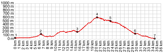
This well defined pass crosses the
ridge directly adjacent to the Mediterranean
sea, above the village Moclinejo.
From West. (described
downwards) On top is the last view of a
landmark ridge to the north: El Torcal.
Looking down the other side, the white patches
between here and the blue hazy sea are not all
just solitary houses, some are clustered together
into dense village space. The first village is
Moclinejo. But the buidings change appearance ever
more as the road descends. They are still white
washed and clustered together like a honey comb.
However the organic patterns of houses, built
individually and long ago, is slowly replaced by
modern, simultaneously developed cookie cutter
condo structures. You can observe the transition
with every meter you roll closer to the coast. I
find many of these still very picturesque, but in
a "let's populate Mars" kind of way. All the
traffic around here seems restricted to the
coastal road. A Dayride with this point as intermediate
summit is on page: Puerto de
Santopilar |
|
|
advertisement |
|
|
advertisement |