| |
| |
Col de la Machine via D2 s(u) For many people "Col de la
Machine" is a euphamism for a 2km section of
road at its top, known as "Combe de Laval" - an
amazing piece of road engineering, chizzled into
a cliff. Col de la Machine itself is just a
little higher than that infamous stretch of
road. Also, Col de la Machine is never a two-way
summit point. No matter what road you use to
approach it, you have to go just a little higher
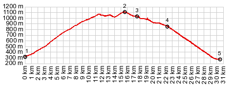
to complete a loop. This profile shows the most direct
loop route over Col de la Machine. The summit on
this route is about 100 meters higher than the
pass. There are many other loop possibilites
over other summit points.
From South. (described
downwards). Just a short roll leads to the
junction with D76. In reality the actual point Col
de La Machine is located just a few meters,
turning left near this junction, instead of right
as the profile does. A peaceful looking tree sits
at the pass - next to that singular comfortable
picnic bench. The profile turns right immediately
before this point and descends to
St-Jean-en-Royans. But usually, none of the preceding description,
is what anybody has in mind, when they talk about
Col de La Machine. It is the next couple of kms of
road, somehow chizzled into the limestone cliff
with 19 tunnels, galleries and wild curves between
pinnacles of rocks. That's what they have in mind.
The section of road was already plainly visible
from the summit point of this ride. but from such
a distance, the view gave hardly any hint of the
intricacies in the road. I'll let the pictures do
the describing. They are better at it. The long rolling descend following this spectacle
leads into St Jean en Royans, and there are
several more reasons to stop and turn around.
A page with this point as intermediate summit is on page: Font D'Urle s(u) History The machine in the name goes back to the 18th century. Back then logging started to take place on the top of the plateau. The first road crossing the plateau between La Drome and the Valle d'Echevis was constructed 1844 and 1851. In the 18th century, the monks decided to exploit the mines in the area. For this they needed a lot of fire wood, and that was on top of the plateau. A set of cranes were installed on the Col de la Machine to hoist the wood into the valley. This crane is the machine in the name referred to in the name of the pass. The two lower tunnels "the tunnels of the monks" were constructed during that time. Traffic traveled over the plateau itself on a route east of Echarasson and its plateau. In 1868 a new route was built over the Col de 'Echarasson, in order to exploit the forest the nearby foret de Lente on top of the plateau. This road still avoided the Combe de Laval, which is such an attraction today. When riding both routes on a bicycle this may still seem like the easier route, even though it is longer and higher. But thinking about the effort it must have taken to blast the 11 tunnels ... The road itself was opened in 1898 after five years of construction. It is fairly obvious that explosives played a big role in the risky construction of this project. While "black powder" has been used since the 19h century, dynamite was still a relatively new invention from 1867, and one can speculate that this was a kind of play- or testing ground of what this new kind of explosives is all capable of. 15 years later the world was about to learn what else these new explosives are capable off in the hand of mankind, during WW1. Here is a link that describes the history in more detail: https://romans-patrimoine.fr/patrimoine/histoire/21-desenclavement-du-vercors-ouest.html |
|
|
advertisement |
|
|
advertisement |